Weather
I think you do a wonderful job. I was very disppointed in the amount of snow that fell yesterday. What happened to the three inches? Do you see snow in the near future? I would love for my children to get to play in the snow.
Posted — Updated
By Lisa Taylor
MIKE MOSS SAYS: Lisa, Thanks for the kind words. Right now, there aren't any indications of more snow in our immediate future. However, it does appear we'll continue with colder than normal temperatures on average for the next week or two, and it certainly wouldn't be impossible for some system to develop in that time time frame that could produce wintry weather again.
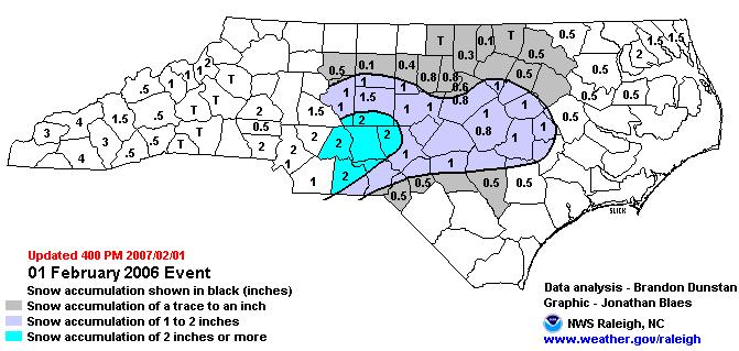
As for the event that occurred on Thursday, it's difficult to address your disappointment about the amounts since I don't know where you live or how much you observed. However, the only portions of North Carolina for which accumulations of up to three inches were expected were across the northwestern Piedmont around the Triad region and points north and west from there. In our viewing area we were forecasting anywhere from a light coating to as much as two inches, followed by a thin glaze of ice, and perhaps up to a quarter inch of ice in some areas north and west of Raleigh.
Bear in mind that that was a forecast for "up to" two inches, and not that two inches would necessarily occur everywhere. As it turned out, the system produced heavier precipitation rates across a band stretching from the southern Piedmont and Sandhills east into the central and southern coastal plain. This heaviest precipitation was shifted a little south compared to our forecasts. As a result, parts of the southwestern and central coastal plain got a little more snow accumulation than expected before the changeover to rain occurred, and likewise precipitation rates across the northwest (Oxford to Roxboro on toward Winston-Salem) ended up with much less snow and ice than were anticipated. Around the Triangle, things worked out pretty close to the forecast progression, except that as snow changed to sleet and freezing rain, temperatures pretty quickly crept up to 33 or 34 degrees and prevented much in the way of glaze ice from accumulating.
The National Weather Service in Raleigh has posted an accumulation map for the storm, a copy of which is shown above. The full size image is available at
http://www4.ncsu.edu/~nwsfo/storage/cases/maps/accum.20070201.gif
Copyright 2024 by Capitol Broadcasting Company. All rights reserved. This material may not be published, broadcast, rewritten or redistributed.


