
By Mike Moss
I guess I should first point out what diurnal is, if I'm going to exclaim in the headline about how some of our weather elements have not adhered to typical diurnal patterns lately. The term "diurnal" as applied in meteorology means, in essence, varying in a regular manner over the course of a one day or 24-hour cycle. There are a number of weather-related parameters that exhibit a strong diurnal variation, including a tendency for winds to be strongest in the daytime and weaker at night, fog to be preferred in the morning and not in the afternoon, relative humidity to be a minimum in the afternoon and a maximum around sunrise, and so on, almost all of which trace back in one way or another to the daily cycle of sunrise followed by solar heating and sunset followed by radiative cooling. The most familiar element of all that has a well-known diurnal variation, of course, is temperature, with a maximum in the afternoon and a minimum around or shortly after sunrise.
However, twice in the past week we've found ourselves trying to word our forecasts and adapt our graphics to a rather atypical progression of temperature and, to some degree, wind variations across central NC. In both cases, we owed the "non-diurnal" effects to low pressure moving northward near or a bit west of the Appalachians, a high pressure center drifting east away from the region over the Atlantic, a fairly well-defined warm front sliding north across our state, and finally a fairly strong cold front sweeping eastward a few hours after the warm frontal passage. Both occasions, by chance, were timed so that the warm frontal passage occurred during the late afternoon and evening hours, when we would normally be cooling down, and, especially this morning, passage of the cold front in the morning, when we would typically be warming back up.
We saw one example of this behavior back on New Year's Eve, and while the warm front that moved in that night did bring some sprinkles and patchy rain along, it made for a comfortably mild, if blustery, outing for First Night visitors. On that day, for example, the Raleigh-Durham airport was 61 degrees at 3-4 pm, about the time of our normal high, with an east wind around 8 mph. By midnight, we had a south-southeast wind at 17 mph (gusting to 23) and instead of falling the temp had risen a bit to 62, and continued up to 65 by 4 am. At 3-4 pm on New Year's Day, instead of warming to a new maximum, we were at 57 degrees with a southwest wind 16 mph gusting to around 25.
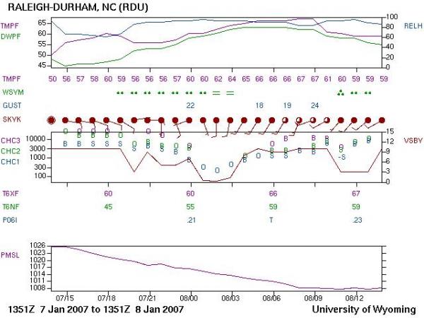
The past day brought almost a rerun, but with perhaps an even more pronounced departure from the typical daily progression (see the graph above, called a meteogram, obtained from the University of Wyoming web site, for a visualization). This time around, 3-4 pm yesterday afternoon saw us at 56 degrees, again with an east wind around 8 mph. Passage of the warm front left us at 66 degrees by midnight, with a south-southwest wind at 16 gusting to 21 mph. We crept up to 67 by 4 am before a band of rain associated with an encroaching cold front moved in from the west. As I write this, it is around 10 am, our temperature is down to 59 degrees with a west-southwest wind around 9 mph, and we appear to be heading for temperatures that drift down into the low to mid 50s by 3-4 pm today, with wind likely to be west-northwest by then, and probably gusting to between 20 and 25 mph.
While a little out of the ordinary, these kinds of non-standard variations are to be expected from time to time, especially during the winter when rather strong frontal systems and low pressure centers are moving across the central and southern sections of the country. During the warm half of the year, when fronts are weak and infrequent and the jet stream and associated surface low pressure centers are typically far to our north, these kinds of days are even more of a rarity.
Copyright 2024 by Capitol Broadcasting Company. All rights reserved. This material may not be published, broadcast, rewritten or redistributed.


