
...And that doesn't refer to just the fact that rainfall is practically non-existent in this region through the warmer half of the year. Actually, I mean that you literally can't take a cool shower here in the summertime. Since most water storage facilities are above ground, and water pipes are buried in some cases but not all that deeply, and with no shading vegetation above, the water that comes out of the "cold" side of a sink or shower here is very nearly as hot as most heated water back home, so that for the next few months at least there is no actual use for the "hot" water line. It startled me a bit the first time or two in the showers, before the realization set in that when highs are in the 110-120 F range and lows only fall to between 80 and 90 F, even the cold water will store a lot of heat!
This week brought an unusual and unique dust event (I can't really call it a sandstorm) that caught most of us in the forecast business off-guard and led to reductions in visibility that were much worse than predicted. A low pressure area that formed over northern Iraq enhanced westerly winds over eastern Syria and westernmost Iraq, generating a massive dust cloud that created a lot of problems for central and western parts of that country during the day. Down toward Kuwait, however, we had entered a pattern that involved lesser pressure gradients and poorly phased winds with height, so our winds were rather light that day and figured to be the next as well. When winds here are as light as we expected, local dust and sand will never restrict visibility all that badly. At the same time, dust plumes with distant sources almost always undergo significant settling, diffusion and dilution that prevents especially low visibilities far downstream. We counted on both those processes working as usual, and computer dust forecasting models we use agreed with that assessment. As it turned out, though, the dust plume to our north and west made a right turn and flowed south into our area during the night, when a developing inversion trapped the dust in a shallow layer, causing it remain more concentrated, and at a time when the relatively light winds in our region further reduced the amount of mixing and dispersion of the plume. By morning, in spite of light winds, we had highly restricted visibility. After the previous sand/dust storms, this was almost eerie, because this time it wasn't hard to breathe, winds weren't blowing like crazy, there was no sand in the eyes or grit in the teeth, just an extremely heavy haze that loomed over everything. The issue here turns out to be one of particle size distribution, as this plume was made up of especially fine lofted silts, and these smallest dust particles have a visibility impact that is out of proportion to the actual amount of material suspended in the air.
We ended up having one more issue with that plume as well - since the back edge had been moving our way, visibility was forecast to improve over Kuwait as the day wore on. It did, very sharply in areas where continued northwest winds pushed the more concentrated dust out into the Persian Gulf. However, those of us within 10 or 15 miles of the Gulf ended up with a seabreeze that pinned some of the dust to the eastern edge of the country, or even captured some of the overwater dust and brought it BACK, so that our visibilities improved only a little and then held steady through the remainder of the day. Once daytime heating gave way to radiative cooling, our seabreeze component died off, winds shifted to north-northwest, and the dust quickly departed.
Now it appears we'll actually have a few days with an interruption to the summer Shamal pattern I wrote about earlier. Winds this week will frequently blow from the east, and we'll actually see our dewpoints climb from around 30-40 F (typical) to about 65-70 degrees. This will make it considerably more uncomfortable out, although we can be thankful air temperatures will decline a bit, from 118-120 the past few days to something closer to 108-112 for a while.
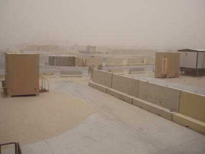
I thought I would try adding a couple of photos to this blog, and see how that goes. The first was taken from a landing just outside my quarters during a moderate dust storm a couple of weeks ago. At the time winds were gusting to between 35 and 40 knots. The still photo gives some sense of the dust in the air, but seems to enhance the contrast a bit over how it appeared to the eye. The second photo from about the same place a day or two later includes yours truly, and is in the same general direction to give an idea how the same scene looks in the absence of the sand and dust. The two story building that can be seen in the background of the second image but not the first is less than half a mile away.
For those who remember the "starch" incident from my last post, the uniform came back and did, as it turned out, have heavy starch, way more than I like. I'll know better if I decide to to back to the same cleaners again!
Finally, just a mention that my team here actually gets to brief weather for back in the States on some occasions. Tropical weather systems in certain areas can be important to some of the usits we support, so we covered Dennis pretty closely last week, and will be keeping tabs on Emily (and Typhoon Haitang) for the next few days.


