
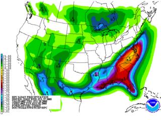
(This image from the Hydrometeorological Prediction Center demonstrates the potential for heavy rainfall here through Monday evening)
Whew!!! It has been another unbearable day across our part of North Carolina and Virginia. We had another record high out at RDU of 102 degrees, breaking the old record of 100 set back in 1949. This may sound masochistic but we were hoping to break the all time high of 105 degrees set back in 1952 and 1988. Hey if we are going to be hot we might as well go all the way right???
Now the weather gets really interesting. We have a cold front that will move into the state tomorrow. At the same time, the moisture increases in the atmosphere with precipitable water values reaching 2". The technical definition of precipitable water is as follows: Total amount of water vapor in a layer of air, expressed in inches. Normally taken between 1000 and 500 mb. Higher values of precipitable water indicate a deep moisture layer, increasing the potential for heavy precipitation amounts. Since the values are so high, we have the potential for heavy rain and perhaps even excessive rainfall.
This cold front will spark showers and storms tomorrow afternoon. They will likely be slow movers and will have the potential to dump heavy rainfall. 1-2" rainfall totals will be common with the storms we see.
ONLY THE BEGINNING!!!
Our cold front will park itself across North Carolina for Friday and into the weekend. It appears due to the jet stream positioning and little waves of low pressure riding along the front, we could be looking at excessive amounts of rain. The Hydrometeorolocial Prediction Center is cautioning the potential for heavy rainfall with totals perhaps exceeding 5-6" by Monday evening. If this indeed is the case we could be looking at localized flooding across eastern and central North Carolina. As they say when it rains it pours!!!


