Well, I see you all have gotten a little bit of a temperature break over the past couple of days, even some cloud cover of note! Not much of either here in Kuwait, as we've had mainly clear skies and temperatures running a little on the high side of normal. We reached 120 here yesterday, 118 today, and may have a "cooling trend" take us down to around 113-115 in the next day or two. At least no more outbreaks of humidity yet - that'll become more common here later in August and early September.
Thought in this post I'd just send over a couple more "Camp Life" photos, and address a very good question that one of our visitors posted as a comment to my last update. Speaking of those comments, if you didn't read them you missed "Lester's" links to photos he took over here while stationed both at Camp Arifjan and nearby at the Kuwait Naval Base, or KNB.
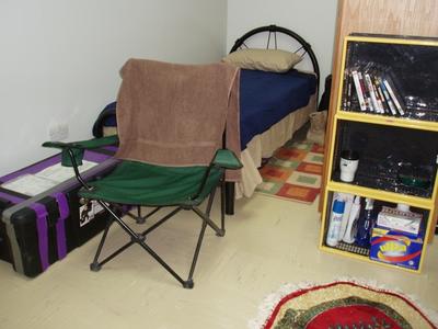
On the subject of photos, here are three more taken in the last few weeks. First, a shot of the little cubby hole I call home for now. Nothing to complain about at all compared to what so many deployed personnel live in, this is one half of a two-person room in a solid building that used to be a warehouse. We get a small bed, a wooden wall locker and there's even a fridge in there. I've stayed in somewhat more spartan accomodations during some recent travel away from here, but this is definitely a nice place to stay under the circumstances...
Next, the entrance to the dining hall where I eat most meals. The food is decent, there's reasonable variety, and there's plenty of it - I'll probably come home a little heavier than when I left! The red barrel with sandbags outside the door is for clearing weapons before entering the facility. It's a way to make sure that on the outside chance that a round is accidentally fired in the process, no one gets hurt (with the possible exception of the pride, and possibly career, of the person who let it happen)...
Finally, this is a me out near the airfield after doing a little maintenence on our weather sensing station. It was about 119 at the time of the picture, the high that day as I remember. The cardboard boxes were put there by the team that preceeded ours to shelter a radio modem that became a little too sensitive to the heat of desert temperatures plus direct sunlight, and has kept communications with the system much more reliable while we work on a more permanent, professional-looking fix...
My last subject is a little bit of an answer to a question posed in response to my last post, that being whether we have special weather products to use over here, or if our data, models and so on are similar to what we use in the States, and whether any of that data is available for those of you back home to see.
The answers are, "a little of both," and yes, some of it at least. Military weather personnel may have to deploy and operate in data sparse locations, with fewer observations, balloon soundings, less radar coverage, and so on than we are used to. However, some of those items we can fill in for ourselves using forward deployed teams and tactical observing equipment. Others we can fill in using satellite coverage and computer simulations, and in some cases we simply have to live with limitations that make forecasting more difficult. This is all a matter of degree of course, as many of the same arguments can be made about weather forecasting even in relatively data-rich environments.
Much of the data we use is publicly available, although in many cases it has been arranged and organized to fit the needs of the miltary, and is provided via web sites that, although not classified, are not made available to the public. This keeps the traffic down and makes the information more reliably available to those who really need it. There are also some sites that operate only through a secured version of the internet, where classified information can be passed along. Historically, reasons for classifying weather information include keeping locations where friendly teams may be taking observations hidden, and denying weather information to the enemy in order to increase our chances of taking tactical or strategic advantage of better-supported, more accurate forecasts.
As for the tools used themselves, they are not unlike and in some cases are identical to civilian counterparts. While the Air Force has a version of the NCAR MM5 forecast model specially adapted to it's needs, for example, it is not extremely different from versions used in civilian applications (our WRAL/NC WeatherScope model is a permutation of MM5), and the same goes for the Navy's COAMPS and NOGAPS models. Both services also make extensive use of the National Weather Service's GFS (Global Forecast System) model, which again is publicly available. We also use satellite data extensively, and much of that is from general use geostationary satellites (the GOES and METEOSAT series), although that is supplemented by some lower-flying, polar orbiting satellites, both specific to the military (the Defense Military Satellite Program, or DMSP) and some flown by NOAA.
As I touched on above, the services have three sets of web sites (and some other communications channels) to support meteorologists in the field or on the seas that range from those completely closed to the "normal" internet, to unclassified but password protected, to some sites that are fully available to the public. While those sites do not fully mirror everything that is avilable to those of us using military systems to access them, they will give you some feel for what's out there, and a means of having a look at what's happening in the atmosphere on this side of the world. For that, I'll leave you with links to a couple of sites you may find interesting.
First, the Air Force's current public weather site. This one used to be somewhat more complete and functional, but was restructured a while back with somewhat restricted capability. Still, you can access quite a bit of worldwide satellite and model data (MM5 and GFS (also called AVN in some places)) by mousing over "Weather Products" and then selecting "Met Info." The starting link is:
https://afweather.afwa.af.mil/index.html
The Navy has a couple of pages that may also be of interest. First, for worldwide output of NOGAPS and GFS, and limited coverage COAMPS models, along with some sea state simulations and so on, see:
https://www.fnmoc.navy.mil/PUBLIC/
TIP: depending on the resolution of your monitor, the map images and animations will fit more nicely if you move the vertical bar that separates the left-side menu over toward the left a ways.
Finally, here is a Navy site that tracks tropical systems around the world, with a bit different view than you get from the NHC site. This makes it easy to see what both our hurricanes and overseas typhoons are up to in one place (just look for any named storm along the left hand side of the page):
http://www.nrlmry.navy.mil/tc_pages/tc_home.html
Happy forecasting!