
The question remains, though, as to how cold and how much precipitation may occur. These continue to be moving targets in the forecast process, and inspire relatively low confidence as to any definitive outlook beyond just a few days. Nonetheless, the Climate Prediction Center now indicates February as having a reasonable chance of being below normal temperature-wise for us, with a modest tilt toward above normal precipitation. However, the 6-10 and 8-14 day outlooks are still fairly inconsistent from day to day, but generally show a continued trend to cooler temperatures.
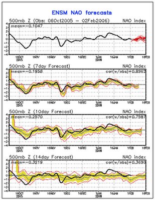
As for outlooks covering the larger scale pattern indices, the North Atlantic Oscillation continues to be forecast negative, though rather weakly so, while the Arctic Oscillation also is forecast negative, and the Pacific North America pattern trends positive (see below). These all point toward cool temperatures for the central and eastern U.S. for at least the next several days to a week, although there is some notable spread in the solutions, and one thing to watch for is them to all swing toward large departures in those same directions as indicators of cold weather, or vice versa. To some extent, it is probably reasonable to take an agreement in sign between the three as a confidence builder, whereas for example a negative AO in combination with a positive NAO would indicate a less emphatic forecast. You can access updated forecasts for these indices anytime through this link.
We've already seen a big drop in temperature over the past couple of days, and a modest storm system passing to our south tonight has some potential to produce rain mixed with pockets of snow over the southern and eastern portions of our viewing area tonight, while a few flurries or sprinkles wouldn't be impossible up in the Triangle region. With borderline temperature profiles and soil temperatures still in the 40s in the wake of recent warm weather, though, this looks to be an event where we're not very likely to manage any accumulations, and overall precipitation amounts have been looking very light north and west of about a Fayetteville to Greenville line.


