
As I write this our rainfall deficit at RDU has risen to 5.90! We are on the verge of transitioning from a moderate drought to a severe drought. This time next week we could be looking at a 7" rainfall deficit if we don't see any substantial rain soon.
Wouldn't you know it, we actually do have a good chance for substantial rain for Monday and Monday night and some light spotty rain for Tuesday of next week.
We will look at the systems and the rainfall potential in the following graphics.
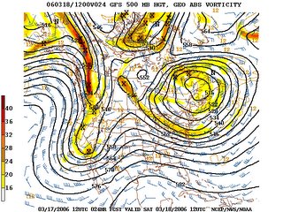
The 500mb flow from the GFS model on Saturday morning at 7am shows a deep trough of low pressure on the West Coast. This trough shifts eastward over the weekend. Over the Plains on Saturday there should be a good soaking. Locations across Texas and Oklahoma are suffering through an extreme to exceptional drought, so what evolves rain-wise will be much welcomed for those folks.
The green displayed on the graphic below denotes the areas of rainfall expected during that time period. This display is for 7am Saturday morning. Notice no rain for North Carolina yet but that will change once we get to Monday. Notice the high pressure center that sits over central Canada. Notice the flow of air around the high. That flow extends into North Carolina. We do have dry, cold air feeding into the state over the weekend.
Here is the 500mb pattern for Monday. That trough advances eastward by this point and flattens out somewhat as it is in the Central Plains over Oklahoma by Monday at 7pm.
The surface pattern for the same time period as the graphic above shows the rain has spread into North Carolina. Notice there is no 'Parent' high pressure system sitting just to our north over New England feeding cold, dry air into the state. The high is well to the northwest sitting just north of Minnesota. It is not in the right position for us to see a sustained frozen precipitation event. If the rain arrives early enough on Monday it could begin as a mix, but the thinking now suggests an afternoon arrival which would allow surface temperatures to rise enough that this would begin and remain a cold rain.
Here is the rainfall expectancy from the Hydrometeorological Center for the time period Friday through Wednesday morning. As you can see this system has the potential to produce inches of rain where it is badly needed in the Plains and perhaps up to an inch of rain across our part of the state.


