
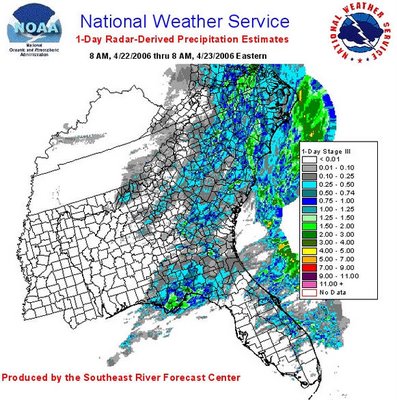
Mike Maze mentioned in his post yesterday that rainfall with the Earth Day weather system on Saturday set a new record for the date at RDU (1.83 inches, topping the 1.31 inches that fell on April 22nd in 1984). The system also produced plenty of rain for much of our area, all badly in need of the moisture. A network of National Weather Service radar rainfall estimates was used by the Southeast River Forecast Center to produce the graphic below, to give some indication of how rainfall was distributed across the region. Note the light green area over northwest Wake county indicates a radar estimate of 1.5 to 2 inches, which squares nicely with the reading from the airport. Likewise, the dark blue and blue-gray across south central Wake County indicates .75-1.o and .50-.74 inches in those areas. I live in that area and had just over three-quarters of an inch in my gauge.
More specifically, here are some gauge readings, in inches for the date, reported from a number of automated stations at airports in the Triangle and surrounding areas. Fayetteville .84, Oxford/Henderson 1.17, Burlington 2.16, Roanoke Rapids .97, Rocky Mt/Wilson .60, Louisburg .15 (seems suspiciously low), Roxboro .32, Goldsboro .39, Sanford .93, Pope AFB .70, Ft Bragg .72, Erwin 1.80. Hopefully, we'll add some to those totals with a modest rainfall event Tuesday night into Wednesday as a cold front, upper level disturbance and wave of surface low pressure all affect the region. That will also leave us with a sizable temperature drop after starting the week with highs in the 80s today and tomorrow...


 for 2024 season")


