
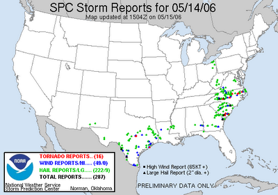
As we'd expected for a few days in advance, the approach of a deep upper level low from the northwest, enhanced by a surface cold front, strengthening mid-level winds and wind shear, low freezing levels and instability fueled by cold air aloft, and finally some periods of sunshine, all translated to a few rounds of strong to severe thunderstorms across central and northern parts of our state on Mother's Day. As seen by the green triangles on the graphic below from the Storm Prediction Center, most of the severe reports in the state were for large hail, much of which was in the 1-2" diameter range. There were a couple of especially large reports, including "tangerine" sized hail in Catawba County, and tennis ball size in Cabarrus. Around our viewing area, several instances of hail in the quarter to golfball size range (1 - 1.75") were received, and we got lots of viewer photos as well, a small sampling of which I've posted in below. There were also several storms in which mesoscale rotation developed, some of which resulted in observed funnel clouds and a few of which led to reported tornadoes, marked on the map in red.
This image of an almost winterlike scene in Stem (southwest Granville County) was sent in by Robin Humphrey, who reports that cars were sliding off the road in spots.
These shots come from the Andersons in Fuquay-Varina. Quite the handful there, as seen in the second shot!
Here's a photo of the hail coming down in Stovall (north central Granville County), courtesy of Tim Faucette.
Alison from the Middle Creek area of Wake County sent the next two photos - as she noted in her message, "WRAL, You said there might be hail!" A few of the stones appear to exceed an inch in diameter.
This comes from Dwight Moss in Garner...
Nice shot of some cumulonimbus mammatus cloud pouches here, from Lewis Dadisman in Fuquay-Varina.
This picture of a whitened deck comes to us from Laurel White, taken in the Crooked Creek area of Fuquay-Varina.
The next 3 images are from Carrie Larsen and were taken around the Rolesville area. They show hail piled on the deck, some "hail fog" resulting from air that's already nearly saturated near the surface being cooled to its dew point as the hail on the ground melts and cools its surroundings. Finally, the last image appears to be a wall cloud associated with a rotating thunderstorm cell, one that may have produced a tornado.
Mrs Powell of the Berea community in Oxford sent this image in. This was hail that fell with one of the early precursor storms that occured during the morning hours over northern parts of our area, well before the main outbreak in the afternoon and evening.
Here's a deck full of hail that Greg Burress sent from around the Hillsborough area. Greg tells us the hail ranged from pea size up to ping pong ball size, and that it beat up the pine trees enough to fill the air with the aroma of pine tar.
Here are some nearly 1 inch stones measured by Dan Courtine in the Apex area. He also sent the second photo of the storm in progress in his neighborhood.
As always, thanks to all of our visitors for taking the time and effort to document the storms this way, and for sending us your contributions. You can see some other images at the WRAL.com Severe Weather Photos slide show.


