
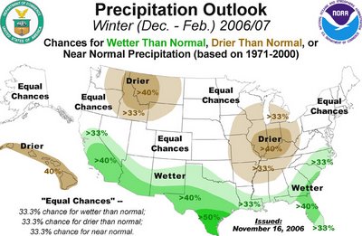
The folks who specialize in long-range forecasting issued their last pre-season outlook for the upcoming winter recently, and it doesn't give us a lot to hang our hats on one way or the other in regards to the likelihood of an active winter across the Tarheel state. The outlooks for the the three month "meteorological winter" period of December through February show some influence of a strengthening but not extreme El Nino pattern in the Pacific, which often results in an enhanced subtropical (southern branch) jet stream moisture transport and disturbance formation across the southern tier of the country, in the form of a likelihood of somewhat above normal precipitation across the deep south and southeast, with central and eastern parts of our state falling within the outer fringes of that area, indicated by the light green shading on the map below.
As for temperatures, most of the state is in an area expected to have a greater than climatological chance of falling, on average, in the "near normal" range, shown on the temperature map below as a light gray shading, while the northern plains and upper midwest states have a high chance at above normal readings. There is a government press release that gives a little more background on the national forecast overall, available at this link.


