Fishel: Irma threatens all of W. Fla.; In Triangle, look for rain Monday, Tuesday
By the time the once-monster storm makes its way far enough north for North Carolina to feel any effects, it will have weakened a long way from the Category 3 that threatens landfall along the west coast of Florida Sunday.
Posted — UpdatedBy the time the once-monster storm makes its way far enough north for North Carolina to feel any effects, it will have weakened a long way from the Category 3 that threatens landfall along the west coast of Florida Sunday.
"The way this track sets up, the whole west coast of Florida is in play," Fishel said.
Hurricane-force winds whipped the Florida Keys, closed Tampa Bay's Skyway Bridge and blew through a largely empty Miami Saturday at the leading edge of the storm.
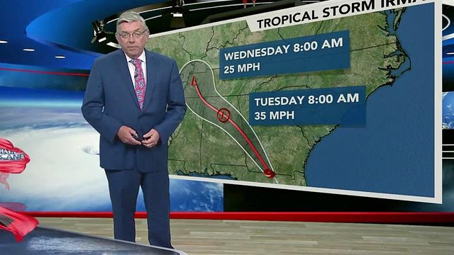
The forecast track puts Irma into southern Georgia as a Category 1 hurricane by Monday afternoon, and remnant rains over Kentucky and Tennessee through midweek, Fishel said.
"Once it gets over land, it will weaken quite a bit wind-wise," Fishel said, "but Georgia, Alabama and Tennessee will still get quite a bit of rain before it's all over."
The U.S. National Hurricane Center's latest forecast projects Irma's potent eye could make multiple landfalls in Florida.
First, there's a projected Sunday morning hit in the Lower Keys. Then later, after moving over water, Irma is expected to come ashore around Cape Coral or Fort Myers. From there it is predicted to steam inland Sunday afternoon over the highly populated Tampa Bay region.
"Tampa is very, very, very vulnerable to this type of storm," Fishel said. "This could be one of the worst situations they've ever seen in that city."
The National Hurricane Center placed the entire Georgia coast under a hurricane watch Saturday as residents packed their cars and trickled onto the highways in six counties under a mandatory evacuation. A hurricane watch was also issued for the South Carolina coast from the Georgia line to Edisto Beach, about 40 miles (65 kilometers) southwest of Charleston.
Gov. Roy Cooper on Saturday said Irma's track continues to look favorable for North Carolina, but the state isn't letting its guard down.
"With the latest storm track, Irma will likely bring heavy rains and wind to North Carolina beginning Monday," Cooper said at a press conference. "While we expect the greatest impacts in the mountains and along the South Carolina border, all regions of North Carolina can expect to feel some wind and some rain."
Cooper cautioned that the rain could bring flash flooding and landslides in the mountains, but emergency management crews were working to identify trouble spots.
That rain could amount to 1 to 3 inches along the South Carolina border, Fishel said. In the Triangle, rainfall totals will be in the half-inch to inch-and-a-half range.
"Monday into Tuesday is the prime time for us to see that rain," he said.
• Credits
Copyright 2024 by WRAL.com and the Associated Press. All rights reserved. This material may not be published, broadcast, rewritten or redistributed.


