Lighter rain, flood dangers follow record downpour
Tropical Storm Fay's remnants swirled through North Carolina, setting off a second round of showers early Thursday afternoon.
"The low-pressure system really starts to fizzle out over the next 24 hours," WRAL Meteorologist Elizabeth Gardner said. "We're still dealing with an unstable air mass, but the craziness of yesterday is unlikely to repeat."
The National Weather Service warns that with the rain-soaked ground, any storms that develop could set off flooding.
Chatham County is under a flood warning until Friday morning. Around 10:30 a.m., the Haw River was running at 13.6 feet, more than 2 feet above flood stage.
A band of storms dumping as much as 2 inches per hour around Wilson prompted an urban and small-stream flood advisory for Wilson and southeastern Edgecombe counties but that advisory was canceled Thursday afternoon.
"Don't go out on the Haw River unless you're an expert kayaker," Gardner said. "Don't go out in your canoe, or they'll be after you to rescue you."
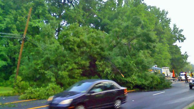
A fallen tree forced police to restrict southbound traffic to one lane and divert from northbound vehicles from North Roxboro Street/U.S. Highway 501 during the morning commute. Urban Forestry crews took several hours to remove the tree.
Teresa Poole said she was driving a black Kia Optima she bought just two months ago when she saw the tree falling towards her.
"I had just pulled out of the community on my way to work, and as I was going down the road, there was a tree, and I was in it," Poole said.
Poole said she swerved and managed to get herself out of the tangled wreck. The tree dented the entire length of the car and cracked the front windshield, and Poole suffered minor injuries and got a neck brace.
But Poole said she's grateful to be alive – and able to make it to her wedding in three weeks.
On Glenoaks Drive in Durham, officials reported that flooding had washed a 1,000-gallon liquefied natural gas tank off its base at a home and into woods, and it was leaking Thursday morning.
On Friday, rainfall will be more isolated as the remnants of Fay move out. A cold front will move in on Saturday, creating a chance for afternoon storms.
Record rainfall floods streets, homes
Raleigh set a new record for rainfall on Aug. 27, with 3.43 inches falling to top the 13-year-old mark.
Heavy rain fell west of Interstate 95 over the past 48 hours: more than 5 inches in Chapel Hill, nearly 4.5 inches in Burlington, and more than 3 inches in Raleigh, Fayetteville and Oxford.
Closer to and east of the I-95 corridor, though, the rainfall totals are dramatically different: approximately 0.60 inches for Rocky Mount and Roanoke Rapids, up to 1.01 inches in Goldsboro.
All that rain had authorities trying to keep drivers off flooded roads and homeowners trying to clean up flooded houses on Wednesday night, particularly in Durham, Lee and Chatham counties.
In north Durham County, a lake overflowed, flooded streets and wound its way into front yards along Mason Road.
"We literally have lakefront property right now, about 30 feet from our houses, and we're in a no-flood zone," homeowner Wanda Guthrie said. "We have been here 11 years, and we have never, ever, ever seen what's going on now."
Six inches of water crept into David Dickson's house on Farrell Road – soaking newly installed carpet. Volunteers with the Redwood Fire Department helped him dry things out.
"The sewer got stopped up and messed up everything I got in the house," Dickson said.
Storms downed at least a dozen trees along a quarter-mile stretch in Silk Hope, Chatham County fire officials said.
Rain came down fast in Lee County, too quickly for the ground to absorb. Ramps from U.S. Highway 1 onto U.S. Highway 15-501 flooded, and crews diverted drivers away from the trouble spot.
Little Buffalo Creek, which locals say a person can normally jump across, widened and rose, nearly touching the bottom of a bridge at Amos Bridges Road in Sanford.
Further down Amos Bridges, a swollen lake expanded over the roadway, prompting John Kroes to abandon his car. Kroes said he deemed it safer to walk home from work, wading through the water.
Franklin County faced a different challenge – three waste water spills to which the heavy rain contributed.
Authorities said 9,500 gallons of untreated waste water was lost during the spills at the Franklinton Pump Station, Cedar Creek and Lane Store roads, and the Industrial Park Pump Station. Crews have repaired the sites, and started clean-up efforts. They remain on site to monitor the situation through the rain event.
Western counties get inundated
Gov. Mike Easley planned to leave the Democratic National Convention in Denver Thursday morning to view storm damage in harder-hit western counties. Easley planned to hold a news conference in Cabarrus County.
Cabarrus officials declared a state of emergency after storms damaged 60 structures and made 11 roads impassable. About 100 home in Mecklenburg County were flooded, some with as much as 5 feet of water, said county emergency management director Wayne Broome.
State Department of Transportation crews have been working since Tuesday to clear rock and mudslides in western North Carolina. The DOT also said off ramps of Interstate 85 at U.S. 52 in Salisbury were closed Wednesday by flooding.
Charlotte got 8.65 inches of rain Monday through Wednesday. Tuesday's accumulation of 5.35 inches shattered a record set in 1891.
In the drought-parched mountains, Asheville received 5.36 inches of rain during the same time period. It also set a record on Tuesday, getting 4.01 inches of rain.


