Local News
State puts map of coastal sandbags online
The map shows the age and location of the sandbags, as well as when the permits were issued, and it has digital photos of the sandbags.
Posted — Updated
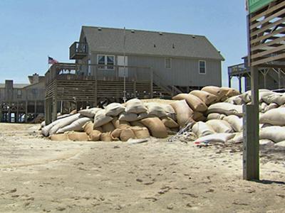
RALEIGH, N.C. — The state Division of Coastal Management on Wednesday launched an online map that documents protective sandbags along the coast.
The map shows the age and location of the sandbags, as well as when the permits were issued, and it has digital photos of the sandbags.
Earlier this year, the state decided to enforce the time limits on some sandbags and force property owners to remove them. Letters go out this week to some of the property owners.

Copyright 2024 by Capitol Broadcasting Company. All rights reserved. This material may not be published, broadcast, rewritten or redistributed.


 for 2024 season")


