Log in to WRAL.com with one click using your favorite social network:
OR
Log in using your WRAL.com account:


Wrong email/password combination.

Forgot password?

Register with WRAL.com using your favorite social network:
OR
Register for a WRAL.com account using our web form.

7:19 p.m. • 6-18-13

Weather Forecast for Raleigh

  • Wed: Partly Cloudy.
    • Hi: 85° F
  • Thu: Partly Cloudy.
    • Hi: 85° F
  • Fri: Partly Cloudy.
    • Hi: 85° F

Other Locations

> 7 Day Forecast

Doppler Image

Alert

Published: 2012-10-28 18:07:00
Updated: 2012-10-28 21:07:58

Sandy brings rain, wind, snow to NC


Regional Radar
Regional Radar
print friendly

Slow-moving and huge, Hurricane Sandy will continue to bring wind, rain and even snow to North Carolina through Tuesday, WRAL Chief Meteorologist Greg Fishel said Sunday.

"The scary thing about this storm is that is such a huge storm in terms of size and how many people it will impact," Fishel said.

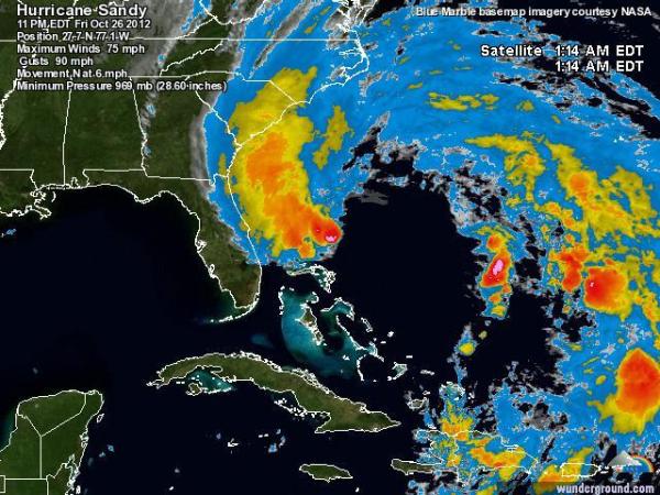
At 8 p.m. Sunday, Sandy was packing 75 mph winds, and its center was 400 miles east-southeast of Raleigh, moving northeast at 15 mph. It's expected to turn to the northwest and make landfall somewhere along the New Jersey coast late Monday or early Tuesday, then continue inland as far as the Great Lakes.

So far, North Carolina has seen a storm surge as high as 3.5 feet at Duck, 5.78 inches of rain at Hatteras and 40 mph wind gusts throughout the coast.

The wrap-around moisture from the large hurricane will give North Carolina alternating periods of dry sunshine and rainy clouds on Monday.

The heaviest rain will move to northeastern coastal counties. In the Triangle, light showers could fall at any time of the day, but the best chance for rain will come during the evening, around rush-hour. Winds will gust between 30 and 40 mph.

Very different precipitation will fall in the mountains.

 "It may bring a significant winter storm to the mountains of North Carolina," Fishel said.

By Tuesday, between 4 to 8 inches of snow could have fallen, with some higher elevations maybe getting a foot.

The cold will also come to the Triangle Tuesday, as central and eastern North Carolina dry out from Sandy.

The high will be around 46 degrees on Tuesday and 55 degrees Wednesday. Overnight lows both days will be in the 30s.

"It's going to be very chilly for the trick-or-treaters," WRAL metereologist Aimee Wilmoth said.

 By next weekend, the mercury will creep back into the mid 60s under sunny skies.

  • Web Editor: Anne Johnson

0 Comments


WRAL.com welcomes your comments on this story. All comments are moderated prior to publication based on our posting guidelines. Please review them prior to posting and if your message is not approved.

View Comments 0 COMMENTS

This story is closed for comments.

View Comments 0 COMMENTS
WRAL Weather on Twitter
  1. nsj: Warned storm is just west of Red Oak, north of Nashville, moving east toward I-95. If along I-95 near Dortches, find shelter!
      — Tuesday, June 18, 2013 7:17 PM
  2. nsj: If you're taking shelter, follow our coverage http://t.co/c8YLJaJLZ5
      — Tuesday, June 18, 2013 7:15 PM
  3. nsj: 7:12pm Storm circulation for southern storm has crossed 64 just S of Spring Hope. Folks along 64 - prep for shelter… http://t.co/vBhHpWL2KV
      — Tuesday, June 18, 2013 7:12 PM
  4. nsj: One round of storms has come through eastern Franklin - round two coming. Stay inside until it's all done.
      — Tuesday, June 18, 2013 7:09 PM
  5. nsj: Circulation on storm along of US-64, SW of Spring Hope, appears to be tightening up. Folks there and in Momeyer should be ready to shelter.
      — Tuesday, June 18, 2013 7:07 PM
  6. nsj: Rotation with cell just east of Zebulon producing a broad hook but still fairly broad at this point. Watching very closely.
      — Tuesday, June 18, 2013 7:04 PM
  7. nsj: Debris signature with storm near Red Oak & NW of Spring Hope has all but disappeared at this point, which is good news.
      — Tuesday, June 18, 2013 7:02 PM
  8. nsj: Tornado warning still posted for Franklin and Nash through 7:30. Main circulation of concern crossing into Nash near NC-56/Nc-58/NC-581.
      — Tuesday, June 18, 2013 7:01 PM

Follow: WeatherCenter | Maze | Fishel | Gardner | Johnson | Wilmoth