Skies clear with warm-up on way
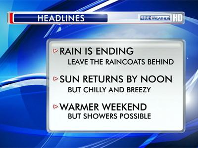
By late afternoon, temperatures should recover into the mid-50s, and that is just a preview of a warmer weekend on the way.
Posted — Updated
Many Triangle communities saw temperatures dip toward the freezing mark overnight. The wind and rain that lingered from Wednesday combined to make for a miserable, bitterly cold morning. By lunchtime skies had cleared but the cold remained. The thermometer at Raleigh-Durham International Airport read 46 degrees at noon.

As the sun sets Thursday evening, temperatures will fall quickly under clear skies and settle in the upper 20s overnight.
Highs will peak in the upper 50s to near 60 degrees Friday afternoon, and highs over the weekend will climb back into the 60s.
"Our temperatures are up and down right now, and we'll see that drastic change over the weekend," Gardner said. "Some places could get close to 70 degrees Sunday."
Clouds will build in gradually beginning Saturday, and the next chance for rain showers arrives Monday and Tuesday.


• Credits
Copyright 2024 by Capitol Broadcasting Company. All rights reserved. This material may not be published, broadcast, rewritten or redistributed.


