Second punch of winter weather to hit Triangle Wednesday
Areas south of Raleigh have experienced the initial blow of the one-two punch of winter weather that will hit the Triangle in less than 24 hours.
Posted — UpdatedAreas south of Raleigh Tuesday experienced the initial blow of the one-two punch of winter weather that will hit the Triangle on Wednesday.
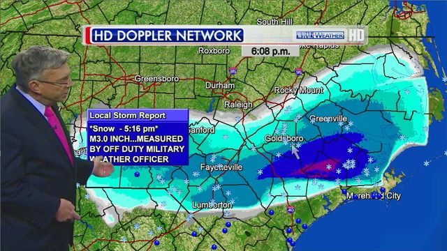
About four inches of snow fell in Fayetteville on Tuesday. Precipitation in areas south of Raleigh tapered off by 9 p.m. Areas directly south of U.S. Highway 64 experienced up to an inch of snow.
Temperatures overnight Tuesday are expected to dip to the mid-20s. While only a freezing drizzle or a few flurries are expected, icy patches on roads are likely.
One person was killed and another injured after a vehicle lost control on a snow-covered road outside Aberdeen Tuesday afternoon. Multiple accidents were reported in Fayetteville.
Interstate 95 was shut down in both directions south of Fayetteville at mile marker 46 (near N.C. Highway 87) Tuesday evening due to multiple weather-related accidents.
Brunt of the storm
Fayetteville will be among the first areas to experience snow, sleet and freezing rain Wednesday morning as a new winter storm moves in from the south. Snow is expected to reach the Triangle by early afternoon and continue overnight.
Temperatures are expected to reach 32 degrees Wednesday.
“Many of us are going to see a variety of different types of precipitation before it’s over,” WRAL Chief Meteorologist Greg Fishel said. “This covers a tremendous chunk of real estate.”
Eastern North Carolina will mostly experience a mix of ice and rain. The Triangle will receive up to 6 inches of snow, while the Triad and areas further west will receive more than 8 inches.
“We’ll have a mix of snow and ice here, and for some in our area, there may be enough ice to cause scattered power outages,” said WRAL meteorologist Nate Johnson.
Ice accumulation will range from .25 of an inch in the east to up to half an inch around Raleigh.
“Anything greater than a quarter of an inch can cause power outages due to ice accumulation on power lines,” Fishel said. “The National Weather Service is saying this could truly be a historic ice storm in terms of impact.”
The storm is expected to leave the area on Thursday.
Storm impact
The ice could lead to widespread power outages, Fishel added.
“The power outages tomorrow night could get to be a big deal,” he said.
The majority of the state will experience some sort of impact from the storm. Gov. Pat McCrory declared a state of emergency Tuesday morning as much of the state was placed under a winter storm warning.
"Here we go again, but this time it may be even more serious," McCrory said. "It's probably going to be more unpredictable. Our goal is to be over-prepared and, hopefully, underwhelmed by the storm. Again, like two weeks ago, this storm is going to be impacting the entire state."
A number of districts will close schools on Wednesday, including Wake, Cumberland and Johnston counties.
"If we have enough reliable information, the decision to cancel or delay school may be made the night before the snow day," Wake County schools said on its Facebook page. "If the decision is made the night before, it will be made in time for the closing to be announced on the 11 p.m. news, whenever possible. In many cases, however, the decision is made the morning of the potential snow day. In this case, the decision is made no later than 4:45 a.m., whenever possible."
Wake schools made the announcement just after 11 p.m. Tuesday.
Durham Public Schools will close 3.5 hours early on Wednesday. Orange County Schools will close two hours early.
Wednesday afternoon and Thursday morning classes at N.C. State University and N.C. Central University were canceled.
• Credits
Copyright 2024 by Capitol Broadcasting Company. All rights reserved. This material may not be published, broadcast, rewritten or redistributed.


