Snow to taper off, cold to linger
"Everywhere that is slushy now will freeze over, making conditions rather treacherous on the roads again Wednesday morning," WRAL meteorologist Elizabeth Gardner said.
Posted — Updated
"We're beginning to see it taper off," Gardner said. "The snowfall is over along the Virginia border and in the western and southern parts of the WRAL viewing area." She said the snow would continue to taper off from west to east through the remainder of the day.
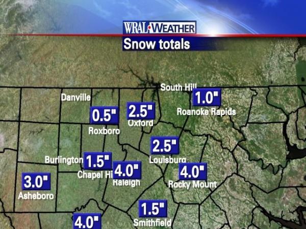
More snow fell in and around Raleigh, Chapel Hill, Durham, Carthage, Smithfield, Rocky Mount, Pittsboro and Lillington. Less of the white stuff accumulated along the Virginia border – from South Hill in Virginia southwest back to Roxboro.
After the snow, skies will clear overnight and temperatures will fall through the teens.
"Everywhere that is slushy now will freeze over, making conditions rather treacherous on the roads again Wednesday morning," Gardner said.
"Once the sun comes out Wednesday, that plays a big role in how quickly the roads can be cleared," she added. Skies should be clear enough to allow for the ice and snow to melt, even though forecast highs are only in the 30s.
By Thursday, a high in the upper 40s should finish off any remnants of the snowfall, Gardner said.
"Once we get to 48 (degrees) Thursday, that should wipe things out," Gardner said.
The weekend weather will feel downright balmy after the recent run of cold weather. Daytime highs are forecast to be in the 50s – close to normal for this time of year.


• Credits
Copyright 2024 by Capitol Broadcasting Company. All rights reserved. This material may not be published, broadcast, rewritten or redistributed.


