Coastal N.C. under tropical storm warning
The first bands from a tropical depression rolled over central North Carolina Friday evening, and more rain is expected on Saturday and Sunday.
Posted — Updated
Tropical Depression Three is predicted to spawn more storms and rains, particularly in eastern North Carolina, as it tracks up the coast from Georgia this weekend.
A band of heavy rain formed over Johnston County around 4:30 p.m. Friday and moved north and west into Wake, Chatham, Durham, Franklin Halifax, Lee and Moore counties.
"Way out ahead of this (tropical) system, we’ve got some bands which are producing locally heavy rains, and they’re moving across our area right now," WRAL Chief Meteorologist Greg Fishel said on Friday evening.
Shortly after 11 p.m., 0.60 inches of rain had fallen in Raleigh, and 1.11 inches in Louisburg. Fayetteville got 0.23 inches, while Erwin, Clinton, Rocky Mount and Chapel Hill all recieved under one-tenth of an inch.
The rain prompted a flood advisory for Wake, which expired at 7:15 p.m. A flood advisory cautions that minor flooding could occur along small streams, roadways and in urban areas with poor drainage.
The system is predicted to move north along South Carolina's coast throughout the day Saturday and cross into North Carolina in the evening. It will likely follow North Carolina's coast throughout Sunday before moving off into the Atlantic in the evening.
"All the models are in agreement that this system is going to track right along the coast, maybe just offshore, as it heads on off to the north and east," Fishel said.
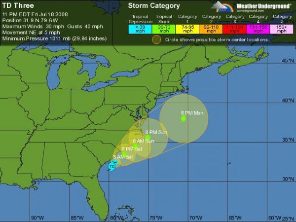
The National Weather Service declared the system a tropical depression at 11 p.m. Friday. It had sustained winds of 30 mph and gusts up to 40 mph, and was located at 31.9 degrees north latitude and 79.6 degrees west longitude.
To be classified as a tropical system, a storm must have its warmest air in its central core. That warmer spurs the formation of rain that's heavier and more intense than those generated by regular coastal storms, such as nor'easters. High winds, though, tend to be more widely spread in coastal storms than in tropical systems.
How much the storm intensifies depends on whether it stays over the warmer waters of the Gulf Stream or tracks more inland.
Its exact track will also greatly affect which areas receive rainfall, Fishel said.
"That would give the heaviest rains to the coastal areas this weekend and also the greatest wind," Fishel said. "And then back in our part of the state, we’d be back on the western fringe, picking up much less in the way of rain."
Off Topsail Beach, the disturbance caused what appeared to be a waterspout around 10:30 a.m. Friday.

• Credits
Copyright 2024 by Capitol Broadcasting Company. All rights reserved. This material may not be published, broadcast, rewritten or redistributed.


