Local News
Weekend Ends With Heavy Rain, Flooding
Wake County was under a flash-flood warning until after midnight, as lines of storms and heavy rain pushed across central and eastern North Carolina overnight.
Posted — Updated
RALEIGH, N.C. — Slow-moving lines of heavy rain and storms dumped between half-an-inch and 3 inches of rain across central and eastern North Carolina late Sunday and into the early hours of Monday.
The large amounts of rainfall prompted the National Weather Service to issue a flash-flooding warning for Wake County, which expired at 12:45 a.m. Cumberland County had also been under a flood advisory for much of late Sunday.
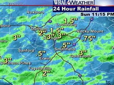
Radar indicated 24-hour rainfall totals of 3 inches for Raleigh, Cary, Southern Pines and Asheboro at 11:15 p.m. A NWS spotter said Goldsboro received 2.5 inches of its 3-inch total within 50 minutes on Sunday evening.
Fayetteville and Durham both got 2 inches, while totals of 1.5 inches were reported in Louisburg and elsewhere in Wake.
Rocky Mount received 0.75 inches, and Smithfield and Erwin both chimed in with 0.5 inches each.
In Raleigh, Crabtree Creek at Old Wake Forest Road was at 10.9 feet and rising steadily at 10:15 p.m. The creek reaches flood stage at 12 feet and places secondary roads near Atlantic Avenue underwater at 13 feet.
Flooding forced police to close sections of Atlantic Avenue for about a more than a half-an-hour around 8 p.m.
Dispatch officials confirmed that Raleigh firefighters responded to reports of flooding in a building at the Cedar Point Apartments on Sandy Forks Road around 8 p.m. The extent of the flooding was not known.
With more rain on the way, police urged motorists to use caution and remember that a foot of flowing water is powerful enough to sweep vehicles off the road.
Duke Power reported that nearly 1,000 people were without power in Durham County around 11:30 p.m. That number had been as high as 2,500 three hours earlier.
The NWS reported a tornado near Spring Hope, in Craven County, and 12 miles northeast of New Bern, in Beaufort County, at 4:25 p.m. Penn-sized hail reportedly fell in Wendell.
At one point, Wayne County was threatened with flooding, and severe-thunderstorm warnings were issued for Chatham, Johnston, Nash, Franklin, Wilson, Randolph, Alamance and Guilford counties.
As a low-pressure system moves up the Mississippi Valley on Monday, a strong cold front will sweep east through the Triangle, bringing another around of showers and thunderstorms.
“As it (cold front) comes on in to the area late tomorrow (Monday) it will help to flare up showers and thunderstorms and could help to produce some strong or potentially severe thunderstorms in one or two spots,” WRAL Meteorologist Moss said.
Once the front moves through Monday, cooler weather will follow for the early portion of the work week.
"Tomorrow, the cold front … will give us a good chance of shower activity, and it could be heavy in spots and perhaps some intense thunderstorms. .... Central and eastern parts of the state (will be) under a slight risk for severe thunderstorms, and the main threat of those would be an isolated, strong wind gust in spots,” Moss said.


• Credits
Copyright 2024 by Capitol Broadcasting Company. All rights reserved. This material may not be published, broadcast, rewritten or redistributed.


