
But a Raleigh firm has a hi-tech way to find your way around town. Imagine a photograph of North Carolina you can view on your computer.
Now imagine being able to follow Interstate 40 across the state and even see cars. Photographs like that are being produced by a Triangle company in partnership with a Russian space agency.
Later this month a Russian Soyuz rocket will put a reconnaissance satellite into orbit. It will be the first true commercial use of its type in space to acquire imagery using converted spy satellite technology.
The satellite's cameras will send back thousands of photographs and digital images of earth including the southeastern United States.
It's been done before and the high resolution pictures are marketed around the world by Aerial Images of Raleigh.
Choose Washington, D.C. Zoom in and the US Capitol is clearly visible.
The new satellite will accurately photograph seven southeast states including North Carolina.
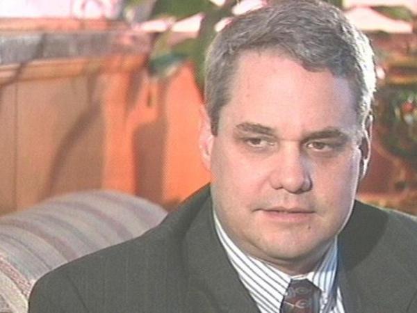
According to John Hoffman, "You'll be able to look at this one image, and pan from Murphy to Manteo." Hoffman says people will be able to zoom down to the detail of cars, parking lots, houses and other structures.
Governments use the photographs to plan and monitor development and environmental issues. Timber companies monitor woodlands and cellular phone companies plan tower placement with the images.
Some people worry that detailed pictures like this may violate privacy.
Objects smaller than two meters across are not recognizable.
Hoffman says that police helicopters and airplanes fly over communities every day and have a far better picture of what's going on than what can now be seen from space.
Photographs and digital tapes are stored in a secure vault alongside powerful computers that pass images to the Internet.
Aerial Images is partner with Microsoft, which also makes images available to the public. Costs vary, but Hoffman says satellite pictures save time and money when it comes to mapping the earth.
Several other US companies plan to launch satellites to do mapping. But Hoffman says his company is the only one that offers the scope and detailed images the Russian satellite provides.
• Credits
Copyright 2024 by Capitol Broadcasting Company. All rights reserved. This material may not be published, broadcast, rewritten or redistributed.
 for 2024 season")


