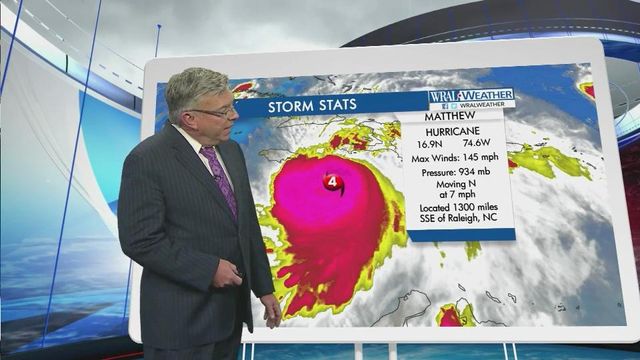
Models show Matthew moving close to NC coast; impacts unclear
Temperatures will remain mild and skies will remain cloudy in the Triangle this week as meteorologists closely monitor the path of Hurricane Matthew, a category four storm that could reach North Carolina's coast by the weekend.
Posted — UpdatedThere's still a lot of spread in the model tracks for Hurricane Matthew late this coming week," said WRAL meteorologist Nate Johnson, "and we can't rule out a landfall or significant impacts here in the state."
According to the U.S. National Hurricane Center in Miami, Matthew is expected to pass across or close to the southwestern tip of Haiti Monday before reaching Cuba Tuesday. At 12 p.m. Monday, the storm had sustained winds of about 140 mph and was moving north at 6 mph.
WRAL meteorologist Elizabeth Gardner said Haiti is on the most dangerous side of the storm.
"Haiti could see anywhere from 15 to 20 inches of rain," she said, "which will cause devastating landslides and flooding."
Matthew won't approach North Carolina's coast until much later in the week.
"Around 8 p.m. on Friday, the storm could be sitting off the coast of Georgia, South Carolina and North Carolina," Gardner said.
Despite the fact that many models keep the storm out at sea, Wilmington as well as Myrtle Beach and Charleston, SC are in the forecast cone, according to the National Weather Service. Gardner said this does not mean that the storm will have a direct impact on the area.
"It's a little too close for comfort, but a lot of the computer models want to shift the storm back out to the north and east," she said. The speed of the storm and the intensity of a cold front will determine this week how close Matthew will get to North Carolina's coast.
"We're expecting a cold front to come along and nudge that storm offshore," said Gardner, "but it's way too early to tell exactly what will happen here."
Even if the storm remains offshore, it could have significant impacts on North Carolina, particularly in the Outer Banks and on the Crystal Coast.
High temperatures will top off in the mid-70s in Raleigh this week, and little to no rain is expected as meteorologists track Matthew's path towards the coast.
• Credits
Copyright 2024 by Capitol Broadcasting Company. All rights reserved. This material may not be published, broadcast, rewritten or redistributed.


