Milder temps then snow could follow harsh temperature drop
A stark temperature change chilled the Triangle Sunday, and a chance for a light mid-week snow remains.
Posted — UpdatedAn airmass change combined with clear skies and low humidity allowed temperatures to become much colder on Sunday than they were Saturday.
"Winter made a big comeback from temperatures in the 70s to 30s for highs," Wilmoth said.
By Sunday evening, the windchill was already in the teens in Raleigh and temperatures were only expected to get colder overnight.
Duke asks customers to conserve energy during cold snap
As frigid air settles into the Triangle, Duke Energy Progress on Sunday asked customers to reduce electricity use until 10 a.m. Monday to help avoid higher stress on mechanical equipment used to generate and deliver electricity.
With the demand for heat increasing as temperatures dip, Duke Energy said customers could lessen the potential for isolated power outages during the period of high demand by:
- Reducing their thermostat to the lowest comfortable setting and lower the thermostat when not at home
- Turn off all unnecessary lighting
- Postpone household chores that require electrical appliances
- Operate ceiling fans in a clockwise direction to push warm air back down into the room
- Leave drapes or blinds open to allow the sun to help warm the house
Will the Triangle see snow?
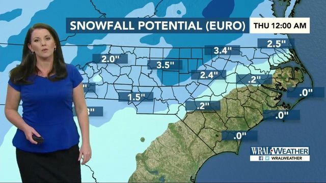
Although current models differ on how much snow could come to North Carolina, both agree that the potential to see some of the white stuff exists Wednesday.
Wilmoth said that snow could begin moving in late Tuesday night and last throughout the day Wednesday. The American Model shows that southern counties could see about a trace to half an inch of snow while counties to the north could see about 1 to 2 inches. The European Model is forecasting even more snow, estimating northern counties could see as much as 3 inches while the Triangle gets 1 to 2 inches and southern counties see only a trace.
"Just plan for the potential for some light snow as we head into Wednesday," said Wilmoth, who noted that it is still too early to be sure just how much snow, if any, will fall.
If snow makes an appearance though, it could create messy conditions as temperatures will dip into the teens Wednesday night.
"If this does in fact happen, we could have some impacts on area roadways, but it's still something we have to keep an eye on," Wilmoth said.
• Credits
Copyright 2024 by Capitol Broadcasting Company. All rights reserved. This material may not be published, broadcast, rewritten or redistributed.


