Hermine's faster track, decreased wind speeds are good news for NC
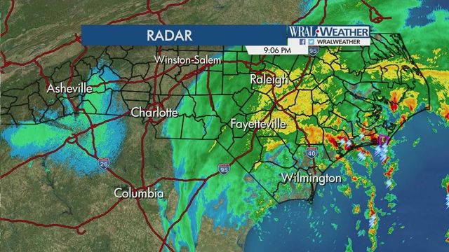
The outer bands of tropical storm Hermine began bringing rain to the state Friday morning, but the storm's increased speed could mean slightly less rain for North Carolina.
Posted — UpdatedAt noon, the tropical storm was about 272 miles southwest of Raleigh and moving north-northeast at about 18 mph. It had maximum sustained winds of about 50 mph.
WRAL meteorologist Elizabeth Gardener said that winds could further decrease by time the center of the storm reaches North Carolina and Hermine's faster speed means good news for the state.
"The faster the system moves, the less time it has to dump rain on us," she said.
Johnston County Schools will dismiss at their regularly scheduled times Friday, with the exception of Early and Middle College, which will release two hours early.
Wake County Schools said that all after-school activities after 6 p.m. on Friday will be canceled due to weather.
The storm will push through Georgia and South Carolina Friday before arriving in North Carolina late Friday.
Rain was falling across much of the Southeastern portion of the state by mid-morning ahead of the storm's center of circulation, which was in Georgia Friday afternoon.
'By the time the center of circulation arrives, most of the [rain] impact will be over," said Gardener.
There is also a small risk for tornadoes Friday night, especially in eastern counties. Several counties in South Carolina and two in North Carolina were under a tornado watch Friday morning.
"They generally don't do a lot of damage and they don't last very long," Gardner said of tornadoes associated with tropical systems.
The Triangle could see 2 to 7 inches of rainfall by the time skies begin to clear on Saturday afternoon but WRAL meteorologist Mike Maze said that northernmost counties may not see any rain at all as the system struggled to move north Friday afternoon.
Sustained winds are estimated to be about 35 mph while gusts could reach 45 mph, although Gardner said those gusts will mostly occur in coastal areas. Saturated ground and gusty winds could create the conditions for trees to fall across the state.
Wind advisories were in effect for Cumberland, Edgecombe, Halifax, Hoke and Wayne counties from 2 p.m. until 8 a.m. Saturday.
"Flooding is going to be a really big threat. Plan not to be on the roads this afternoon, tonight and early Saturday," Gardner said.
State officials are urging residents in North Carolina to be alert for possible flooding as Hermine moves toward the area.
Gov. Pat McCrory said the goal is to be "over prepared and under whelmed" by the tropical system making its way up the East Coast.
"Rivers can rise very, very quickly, so keep clear of those," McCrory said. "Also, do not drive your cars through high water. Be smart, let's get through this storm, and we'll all get to enjoy Labor Day."
McCrory said that rescue teams with boats are prepared to respond to flooding although no major flooding had been reported as of Friday afternoon.
"We've got everything deployed in the right way, especially in eastern and southeastern North Carolina," he said.
McCrory said that even though the forecast was looking positive, especially considering the limited damage reported in Georgia as the storm moved through, people still need to take precautions.
"Don't take this for granted, it could change at a moments notice," he said.
State officials said National Guard soldiers, Highway Patrol troopers and Department of Transportation crews have been mobilized across the state to respond to flooding and other issues.
"We want to remind everyone to not be complacent even after the storm passes because more deaths occur due to flooding than to any other severe weather hazard," said Public Safety Secretary Frank L. Perry.
Flood prone areas were making preparations Friday morning, and signs in the parking deck at the Crabtree Valley Mall warned shoppers that the area is prone to flooding.
Brian Asbill, a spokesman for the mall, said the bottom level of the parking garage along Glenwood Avenue was closed as a precaution because storm drains often overflow in that area. Storm drains in the area were also cleaned in preparation for the storm to prevent back-ups.
In Fayetteville, all city pools will remain closed until at least 1 p.m. Saturday and transit service will stop if winds rise above 40 mph. Engineering crews were pre-staging barricades near flood prone roads, including Ray Avenue.
Duke Energy was moving people and equipment to locations expected to be at greatest risk for power outage as the storm passes.
A handful of flights scheduled to depart from Raleigh-Durham International Airport Friday afternoon were delayed and some flights out of the Wilmington airport were canceled.
The Red Cross in Eastern North Carolina had volunteers on standby Friday afternoon to open shelters and disperse emergency response vehicles when needed.
Steady rain will hold temperatures in the mid-70s across North Carolina at least until the storm moves out.
The holiday weekend won't be a total washout, however.. By Sunday, the sun returns and temperatures climb back into the 80s.
"I'm not going to tell you you're going to salvage Saturday, but certainly Sunday and Monday look good," Gardner said.
• Credits
Copyright 2024 by Capitol Broadcasting Company. All rights reserved. This material may not be published, broadcast, rewritten or redistributed.


