{{sidebar src="sidebar-15262798"}}
Snow, ice, sleet and freezing rain fell Friday across central North Carolina, keeping most schools and businesses closed but creating slick conditions.
Other WRAL Top Stories
By nightfall, 101,000 customers of Duke Energy were without power, including 42,000 in Wake County.
UPDATE 5:55 p.m: Duke Power has reported 20,239 customers have been affected by power outages in Wake County.
–––––––––––––––––––––––––––––
UPDATE 5:45 p.m.:Officials said a tree fell on a house in Selma with a father and son inside Friday evening. The roof and porch were heavily damaged, officials said.
A spokesperson from the Selma Fire Department said they are "responding to trees left and right."
–––––––––––––––––––––––––––––
UPDATE 5:40 p.m.: Interstate 40 is closed in both directions in Johnston County at mile marker 324 due to power lines on the highway.
–––––––––––––––––––––––––––––
UPDATE 5:25 p.m.: Frozen precipitation is causing downed trees and branches across central North Carolina, with many falling on power lines.
–––––––––––––––––––––––––––––
UPDATE 4:45 p.m.: Duke Energy is reporting 45,623 total power outages in North Carolina, including Wake County (9,932), Harnett County (7,467), Johnston County (4,360), Cumberland County (2,803) and Moore County (2,741).
–––––––––––––––––––––––––––––
UPDATE 4:15 p.m.:WRAL meteorologist Nate Johnson said precipitation in the Triangle is changing from sleet to rain, causing wet roads across the area.
–––––––––––––––––––––––––––––
UPDATE 4:10 p.m.: Durham police announced they have reported 40 traffic accidents since midnight.
–––––––––––––––––––––––––––––
UPDATE 4:00 p.m.: Nearly 18,500 customers were reported without power across North Carolina Friday afternoon, according to Duke Energy. Scotland, Moore, Harnett and Hoke were among the greatest affected by the winter weather.
–––––––––––––––––––––––––––––
UPDATE 3:45 p.m.: Chatham County officials said two shelters will open at 4:30 p.m. as a precaution for residents who may need assistance. The two shelters are located at Northwood High School—301 Northwood High School Road, Pittsboro—and Virginia Cross Elementary School—234 Cross School Road, Siler City.
–––––––––––––––––––––––––––––
UPDATE 3:30 p.m.: Wake County officials announced an emergency shelter will be opened at Sanderson High school for people affected by the winter storm, beginning at 3 p.m. The shelter is located at 5500 Dixon Drive in Raleigh.
–––––––––––––––––––––––––––––
UPDATE 3:00 p.m.: WRAL Chief Meteorologist Greg Fishel said temperatures will continue to climb over the next few hours, which should cut down on the frozen precipitation in Raleigh. He added that there will be a lull Friday evening and into early Saturday morning, eventually leading to light snow.
–––––––––––––––––––––––––––––
UPDATE 2:50 p.m.: GoRaleigh bus services announced it will stop services at 8 p.m. due to the inclement weather. The R-Line will end service at 4 p.m. The City of Raleigh has also suspended solid waste collection. Friday routes will be collected on Monday, according to a press release.
–––––––––––––––––––––––––––––

UPDATE 2:35 p.m.: Power outages across the Triangle continue to climb Friday afternoon. Moore County has reported 2,141 power outages, Johnston County has 1,403 without power, and 863 residents in Cumberland County have lost power.
–––––––––––––––––––––––––––––
UPDATE 2:15 p.m.: All Wake County libraries, parks and animal centers, and the Board of Elections, will be closed on Friday.
–––––––––––––––––––––––––––––
UPDATE 2:00 p.m.: A wreck involving a tractor-trailer shut down a section of I-85 in Vance County at exit 213.
–––––––––––––––––––––––––––––
UPDATE 1:29 p.m.: All SAT tests scheduled for Saturday at Wake County Schools have been canceled. Wake Tech Community College also announced all of its campuses and centers will be closed.
–––––––––––––––––––––––––––––
UPDATE 1:17 p.m.: More than 400 flights in and out of Raleigh-Durham International Airport have been canceled on Friday.
–––––––––––––––––––––––––––––
UPDATE 1:00 p.m.: Almost 1,000 people have lost power in Southern Pines, according to Duke Energy's online power outage map.
–––––––––––––––––––––––––––––
UPDATE 12:30 p.m.: A wreck involving a FedEx tractor-trailer closed I-85 northbound at Guess Road, exit 175.
–––––––––––––––––––––––––––––
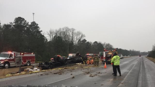
UPDATE 12:17 p.m.: The N.C. State Highway Patrol is reporting four traffic fatalities related to winter weather.
At 8:21 a.m. Friday, troopers responded to a collision on I-95 in Johnston County. The driver of a tractor-trailer traveling south on I-95 lost control of the truck and jackknifed, blocking both lanes of the highway. A pickup truck, also traveling south, then crashed into the tractor-trailer, according to the Highway Patrol.
An unidentified passenger in the pickup truck was killed in the accident. The driver of the pickup was taken to the hospital with serious injuries.
Another tractor-trailer also driving south on I-95 avoided the original accident but traveled off the shoulder, striking a guardrail.
On Wednesday, Rosa Leake, of Kernersville, lost control of her vehicle on Vance Road in Forsyth County. Leake's vehicle crossed left of center and struck a pickup truck head-on, killing Leake.
In Stokes County on Wednesday, Highway Patrol said Mary Bondurant Williams, 60, of 1040 Wilburn Lane, King, died after her vehicle crossed the center line, drove down an embankment and overturned in a creek.
In Wilkes County on Wednesday, Joey Carl Darnell, 44, of North Wilkesboro, died when the driver of the vehicle he was riding in lost control, traveled left of center and struck a Nissan pickup truck head-on. Darnell was taken to Baptist Hospital in Winston-Salem where he later died.
–––––––––––––––––––––––––––––
UPDATE 11:37 a.m.: Chatham County has declared a state of emergency, according to a news release from the county.
–––––––––––––––––––––––––––––
UPDATE 11:29 a.m.: A car spun out on U.S. Highway 15-501 near Cornwallis, crashing into a snow plow.
–––––––––––––––––––––––––––––
UPDATE 11:18 a.m.: Jeff Brooks,spokesman for Duke Energy, said the power company brought in 3,000 additional workers to North Carolina from other states to help handle any power outages that could happen, bringing the total to roughly 6,000.
–––––––––––––––––––––––––––––
UPDATE 10:55 a.m.: Nick Tennyson, state transportation secretary, said trucks put out nearly 2 million gallons of salt brine in anticipation of the storm and have since dropped 12,000 tons of salt and 5,000 tons of sand/salt mixture.
Tennyson said crews can't be everywhere at once, but they're trying to make sure the highest volume areas are being handled first. The state's priority is interstates, then primary routes, then lower volume, secondary roads.
Col. William Grey with the of the Highway Patrol has all available personnel working, though he urged drivers to stay off the roads unless travel is necessary.
"It'll help keep you safe and my troopers safe as well," Grey said.
The two additional fatalities brought the state's total to four since Wednesday night. The first three fatalities occurred on Wednesday evening, McCrory said, while the fourth happened Friday morning on I-95 in Johnston County.
The Wednesday fatalities occurred in Wilkes, Forsyth and Stokes counties.
The N.C. State Highway Patrol said it has towed 19 vehicles as of 9:30 a.m.
–––––––––––––––––––––––––––––
UPDATE 10:40 a.m.: McCrory said there were about 6,000 power outages across the Tar Heel state as of 10:30 a.m. But that number, he said, is expected to fluctuate as the storm progresses and ice begins to build up.
Most of the outages occurred in the mountains and Charlotte region.
The N.C. State Highway Patrol has responded to 571 collisions and more than 800 calls for assistance, McCrory said, and checked 25 to 30 abandoned cars.
–––––––––––––––––––––––––––––
UPDATE 10:35 a.m.: Gov. Pat McCrory said in a news conference the state has implemented the right measures to keep North Carolina safe, but the slick road conditions caused two fatal car accidents.
One person died late Wednesday after being injured in a car wreck in an unidentified part of the state, McCrory said. Early Friday morning, another serious wreck on I-95 killed one person in Johnston County.
–––––––––––––––––––––––––––––
UPDATE 10:25 a.m.: Gov. Pat McCrory will give an update on the state's response to the winter storm. Watch live here.
–––––––––––––––––––––––––––––
UPDATE 9:54 a.m.: The low pressure system behind this winter storm is sitting on the border of Alabama and Georgia, but WRAL meteorologist said the system has to move all the way through North Carolina before the event passes.
–––––––––––––––––––––––––––––
UPDATE 9:22 a.m.: Ice could begin to pile up and coat roads around 5 p.m. on Friday, said WRAL meteorologist Elizabeth Gardner.
Ice could build up to a quarter to a half an inch, Gardner said.
WRAL meteorologist Aimee Wilmoth said Chatham County reported half an inch of snow around 9:15 a.m. Friday, and Orange County saw .4 inches. Person County, though, had reports of 2 inches of snow.
–––––––––––––––––––––––––––––
UPDATE 9:05 a.m.: A reported accident on Interstate 95 has all southbound lanes closed at Bagley Road near Kenly.
The wreck involved a tractor-trailer and a pickup truck near exit 105, officials said. One person was transported to the hospital.
Emergency management is on scene. I-95 southbound has been detoured around exit 105.
Another accident occurred on I-40 westbound at mile marker 335 involving an overturned tractor-trailer.
–––––––––––––––––––––––––––––
UPDATE 8:46 a.m.: Expected snowfall totals have been adjusted across eastern North Carolina as early snow and sleet accumulation is scant.
Much of Raleigh could see 1 to 2 inches of snow and sleet accumulation, down from the earlier expectation of 3.5 inches. Even in the heart of the storm in northern North Carolina and into Virginia, expected accumulation has dropped to between 4 and 8 inches.
–––––––––––––––––––––––––––––
UPDATE 8:34 a.m.: Mike Charbonneau with the N.C. Department of Transportation said there are 70 trucks in Wake County putting down salt and sand to help break up any ice that's forming on roads.
Ahead of the storm, Charbonneau said, the DOT dropped 1.5 million gallons of brine on roads and highways.
Close to 1,000 DOT trucks across the state will be out trying to clear roads.
"Our crews will stay out proactively all day long treating all of the major roads," Charbonneau said.
–––––––––––––––––––––––––––––
UPDATE 8:22 a.m.: The winter storm is beginning to pick up in intensity west of Fayetteville, said WRAL meteorologist Elizabeth Gardner.
The temperature in the city is 29 degrees, and the wind is beginning to pick up, Gardner said, so much of the wetness on the ground currently could turn to ice.
–––––––––––––––––––––––––––––
UPDATE 8:09 a.m.: Wake County declared its own state of emergency following Gov. Pat McCrory's decision on Thursday to place all of North Carolina under a state of emergency.
–––––––––––––––––––––––––––––
UPDATE 8:01 a.m.: Lt. Jeff Gordon with the N.C. State Highway Patrol said there were five traffic accident calls across the greater Raleigh area since midnight, but he expects that to increase as the storm worsens.
"Any time that we have any approaching storm we put all personnel on standby," Gordon said of the highway patrol's response. The highway patrol is working in conjunction with the N.C. Department of Transportation to keep roads safe.
–––––––––––––––––––––––––––––
UPDATE 7:51 a.m.: With temperatures across eastern North Carolina stuck below freezing, any rain coming down is considered freezing rain, said WRAL meteorologist Elizabeth Gardner.
WRAL meteorologist Aimee Wilmoth said wind will play a large factor later on Friday. High wind speeds coupled with freezing rain, Wilmoth said, could knock trees and power lines down.
Roads are showing slight improvements before 8 a.m. because soil temperatures in the mid to upper 30s are helping to melt any accumulation. The Department of Transportation still recommends staying at home, though, because conditions will change later in the day.
–––––––––––––––––––––––––––––
UPDATE 7:24 a.m.: WRAL meteorologist Elizabeth Gardner said there are reports already of roads glazed by freezing rain, but as winds kick up later in the day, the icing will become more of a problem.
Around 2 p.m. Friday afternoon, the western part of Wake County could see close to 3 inches of snow and sleet, while the eastern half of the county might only get 1 inch of accumulation.
The more significant accumulation will be from ice, Gardner said. Raleigh could see a quarter inch to a half inch of ice, which could cause widespread power outages.
–––––––––––––––––––––––––––––
UPDATE 7:16 a.m.: Road crews in Durham are cleaning up sidewalks and patrolling the streets even as the snow has stopped in the city.
WRAL reporter Mikaya Thurmond said the majority of the vehicles on the road in Durham are crews working to clear the snow. Even though the snow stopped suddenly, though, Thurmond said it could start again just as quickly.
–––––––––––––––––––––––––––––
UPDATE 6:49 a.m.: A mix of sleet and snow is coming down around the Triangle, but a wedge of drier air could end the storm earlier than expected.
The Triangle is looking at up to 3 inches of snow, said WRAL meteorologist Elizabeth Gardner.
In the mid to late afternoon, the storm could draw in some dryer air that could shut off the precipitation earlier than expected, Gardner said.
–––––––––––––––––––––––––––––
A wintry mix that could include snow, sleet and freezing rain began falling in much of central and eastern North Carolina before daybreak on Friday, creating a potentially hazardous travel day across the bulk of the area.
Gov. Pat McCrory declared a state of emergency Thursday ahead of the moisture-rich storm, and the National Weather Service issued a winter storm warning for Friday between midnight and 6 p.m. Saturday.
Sleet and freezing rain began falling in the Triangle by 5 a.m., and many areas – especially from Raleigh north and west – began to see snow by 6 a.m.
"It's really starting to come down in parts of the area," WRAL meteorologist Elizabeth Gardner said. "I'd expect road conditions to deteriorate pretty quickly in the areas that are seeing heavier snow."
Communities to the northwest of the state capital – Roxboro, Orange County and even Chapel Hill – will see more snow. To the south, in Cumberland County, and east of Interstate 95, the weekend will be more wet than white.
Accumulation amounts will vary greatly by location, but Gardner said some places could see 2 to 4 inches of snow accumulation and ice accumulation of between a tenth and quarter of an inch.
Ice accumulation could create power outages. Anything greater than a quarter-inch of ice can cause branches to snap and cause widespread power outages.
"Our crews are starting to move out now as we begin to see more snow coming down," North Carolina Department of Transportation spokesman Mike Charbonneau said at 6:15 a.m. "Some of our trucks are heading out with salt and sand. We've been pre-treating, and we'll be trying to get things to melt as quickly as we can."
"Ice creates special problems. You can't scrape it off the road, you have to use sand and salt, so it takes a little longer to clear the roads," Charbonneau said.
In anticipation of slick roads, North Carolina State University and the University of North Carolina at Chapel Hill, Fort Bragg and most area school districts – including Wake, Durham, Johnston and Cumberland counties – will be closed on Friday.
The NWS and governor McCrory advised drivers to stay off the roads except in emergency situations and to be prepared for power outages.
Snow will return Saturday, although amounts will be light.
"We're not expecting any widespread accumulation of snow on Saturday, because we'll be past the main part of the storm," Gardner said.
Travelers are asked not to call 911 or the state Highway Patrol for road conditions so the lines can remain clear for emergency calls.
Driving safely in the snow:
The State Highway Patrol advised drivers to avoid being on the roads if possible.
If you must drive in ice and snow, take these precautions:
- Make sure your battery and cellphone are fully charged
- Fill your gas tank
- Pack bottled water and a blanket in the trunk
While on the road, slow down when roads are slick. Other driving tips:
- Increase your following distance. You should allow about four car lengths for every 10 mph
- Drive slower than the posted speed limit
- Don't use cruise control
- Stay in cleared lanes, or follow in the tracks of other vehicles where possible
- Don't try to change lanes
If your car starts to skid:
- Let your foot off the gas
- Don't slam on the brakes
- Steer into the skid
- Get to a safe place
- If you get stuck, turn on your flashers so rescue and emergency crews can find and help you.