Matthew's rains cross into Carolinas
As Friday turned to Saturday, the hurricane that Carolinians had watched for more than a week made itself felt. Heavy rain was falling over South Carolina in Hilton Head and Savannah, and Hurricane Matthew was expected to make landfall near Charleston before making a turn back out over the Atlantic Ocean.
Posted — UpdatedRain as far inland as Columbia, S.C., and as far north as Fayetteville, N.C., was falling from the outer bands of the Category 2 hurricane.
"This is still a very strong Category 2, with winds of about 112 mph," WRAL meteorologist Mike Maze said.
The main threat for the Carolinas comes from flooding – up to 10 inches of rain could fall in coastal counties through early Sunday – and from high winds that could down trees and power lines.
A hurricane warning was in effect for the North Carolina coast north to Surf City. Tropical storm warnings were also issued from Surf City northward to Duck.
Additionally, a hurricane watch was issued from Surf City to Cape Lookout.
"A hurricane warning technically means there is a chance, or even a likelihood, of hurricane-force sustained winds," WRAL Chief Meteorologist Greg Fishel said. "That all depends on what happens with Matthew over the course of the next 24 to 30 hours. Is it able to maintain, at least, some semblance of the strength it has right now? The overall forecast trend is for it to weaken slowly."
Storm surge warnings were issued south of Cape Fear, meaning tides 5 to 7 feet above ground level are possible in coastal areas. Storm surge watches, meaning tides 2 to 4 feet above ground level, were in effect north of Cape Fear.
At 11 p.m. Friday, Hurricane Matthew was 400 miles south-southwest of Hatteras, and it was already beginning to make an eastward turn. The eyewall had disintegrated on the storm's southern side, an indication, Fishel said, that it will continue to weaken through the weekend and could be at tropical storm strength by Sunday.
Steady rainfall expected through Saturday across the eastern half of North Carolina raises the threat of flash flooding. Wind gusts of up to 50 mph could knock down trees anchored in already-saturated soil, leading to the potential for power outages.
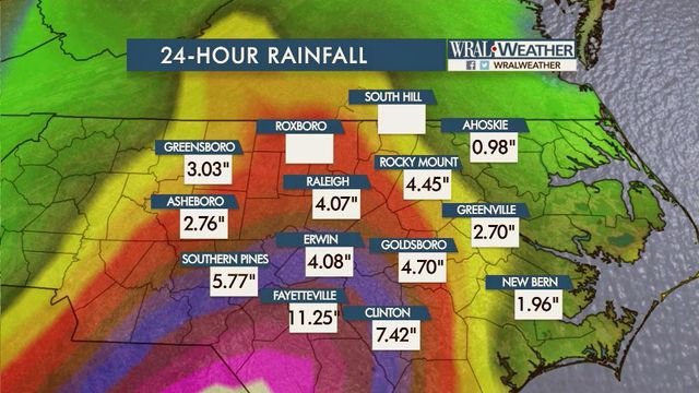
Fishel said the "best chance for double-digit inches" would be to the south and east of Raleigh, but the Triangle also will get a good soaking.
"The real problem is that the amount of rain many counteract any weakening in the wind strength," he said.
Fayetteville and Goldsboro could see 4 to 7 inches of rain, and 1 to 4 inches could drop in Raleigh. Northern coastal towns, such as Hatteras and Elizabeth City, might get 3 to 5 inches.
The rainfall could create more flooding problems for counties already saturated by heavy rain.
"In those areas that had the flooding problems last week, this is the last thing they need," Fishel said.
The National Weather Service said parts of the Triangle could see wind gusts up to 40 mph. The Sandhills will see winds up to 40 to 50 mph at times.
"You're going to notice that wind. It's going to be pretty stiff around here," Fishel said.
High winds and saturated ground heighten the chance for power outages when trees fall on transmission lines.
"I wouldn't rest easy about power outages until about Sunday night," said WRAL meteorologist Nate Johnson.
As the storm spirals away from North Carolina on Sunday, it is expected to continue to drop in intensity. Wind speeds will swirl around 75 mph over the weekend.
"The track uncertainty is huge once it gets off the coast," Fishel said, "but there is no indication of it coming back to North Carolina. The storm's track keeps it in water much cooler and warm to a lesser depth than the Caribbean where it gained strength.
Wind gusts of 30 to 40 mph will linger into Sunday even after the rain ends, according to the National Weather Service.
The state has continued to keep National Guard and rescue teams ready to respond to areas in need. Gov. Pat McCrory on Friday said other medical and evacuation resources will be sent to South Carolina and Florida to help those states deal with what could be the worst of the hurricane.
McCrory said residents in southeastern counties should be prepared for prolonged power outages after the storm. Electric utilities will likely be inundated with work, McCrory said, so it could take a while to get the lights back on.
• Credits
Copyright 2024 by Capitol Broadcasting Company. All rights reserved. This material may not be published, broadcast, rewritten or redistributed.


