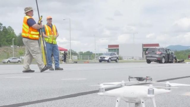
How NC uses drones to help clean up crashes quicker
After a big crash on the highway, police sometimes have to shut down the road to investigate what happened, but new technology could clear those scenes in less than half the time.
Posted — UpdatedThe Highway Patrol always tries to clear a crash scene quickly to prevent big backups, but it takes a long time to take the measurements and photos necessary to reconstruct a crash scene. So, the Highway Patrol asked the North Carolina Department of Transportation to study how troopers could use drones to help.
"(We can use drones) to map a collision scene quickly, safely and to gather the data to the accuracy standards they required," said Basil Yap with the DOT's Aviation Department.
Video of tests from May showed how authorities in Asheville simulated a head-on collision and then used a laser scanner to take pictures of the scene and build a 3D model.
"This helps the investigators recreate that collision and understand all the moving parts," Yap said.
In the Asheville test, it took troopers on the scene about two hours to finish their work. It took the drone only 25 minutes, which means means authorities can open the lanes up to traffic quicker.
The drone technology will also mitigate the danger to first responders: quicker cleanup times mean less time spent in dangerous conditions around moving traffic.
It's just one way engineers said they can use drones to keep traffic flowing.
The DOT right now uses a bigger camera in an plane to take pictures of construction sites, but they can also use the more nimble, cheaper drones for smaller projects.
"We're seeing as this technology develops that it's getting cheaper and cheaper, and we're only going to see those efficiencies improve in the future," Yap said.
Yap said decreasing costs and improved services will mean more eyes in the sky soon.
The Highway Patrol is already starting to use the drone technology for collisions. Yap said municipalities might also begin using it to document crime scenes.
The DOT has six drones working a variety of missions, including mapping the coast to make it easier to assess hurricane damage. Yap said the DOT could also use drones as temporary traffic cameras to monitor congestion during events.
• Credits
Copyright 2024 by Capitol Broadcasting Company. All rights reserved. This material may not be published, broadcast, rewritten or redistributed.


