Log in to WRAL.com with one click using your favorite social network:
OR
Log in using your WRAL.com account:


Wrong email/password combination.

Forgot password?

Register with WRAL.com using your favorite social network:
OR
Register for a WRAL.com account using our web form.

8:57 p.m. • 5-19-13

Weather Forecast for Raleigh

  • Mon: Thunderstorm.
    • Hi: 78° F
  • Tue: Thunderstorm.
    • Hi: 84° F
  • Wed: Partly Cloudy.
    • Hi: 86° F

Other Locations

> 7 Day Forecast

Doppler Image

Alert

  • Just In: The North Carolina Senate on Sunday released a preview of its $20.58 billion budget proposal for 2013-14, which would increase spending by 2.3 percent and offer the largest tax cut in state history. The spending plan closely follows the priorities set forth in Gov. Pat McCrory's budget proposal.

Published: 2012-12-21 05:45:00
Updated: 2012-12-21 14:43:39

High winds blow into Triangle as winter begins


Wind advisory, Dec. 21, 2012
print friendly

Clouds and rain showers associated with a mass cold front moved off the North Carolina coast early Friday, leading into a cloudy and windy afternoon with gusts over 40 mph.

Sustained winds increased across the area all morning, and central North Carolina remained under a wind advisory from 9 a.m. to 7 p.m., WRAL meteorologist Mike Moss said. A wind advisory means frequent wind gusts of 40 mph are expected.

More Info     Wind Speeds, DMA Winds Speeds and Wind Gusts

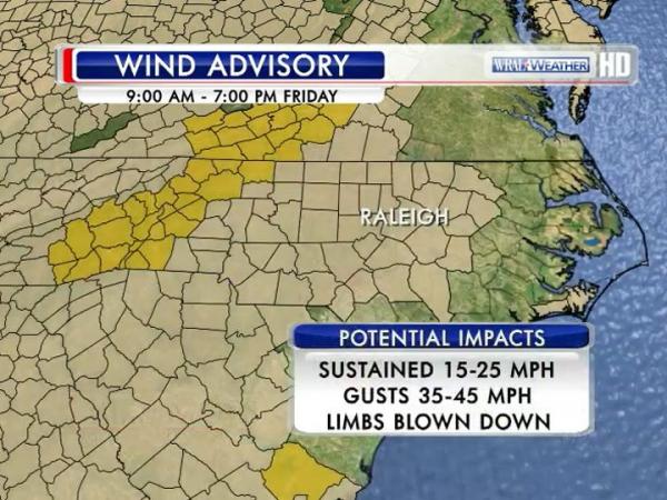
"People driving around today in high-profile SUVs and tractor-trailers today need to use a little extra caution, and we could see a few tree limbs blow down in spots," Moss said. "If you're traveling into the mountains, winds there could gust up to 60 mph."

High winds suspended the Hatteras-Ocracoke ferry route Friday and Saturday. The wind gusts in combination with shallow water depth in the inlet made it unsafe to cross. The Pamlico Sound route from Swan Quarter and Cedar Island to Ocracoke may also be suspended.


Snow flurries were spotted across western North Carolina. WRAL meteorologist Nate Johnson said the highest chance for snow flurries was west of the Triangle.

"This is not a big deal," Johnson said. "There won't be any accumulation."


Sunshine won't help the temperatures climb much, as afternoon highs will struggle to climb out of the 40s on the first official day of winter. The wind will make it feel even more bitter, Moss said. 

"We could see some variable cloudiness as the upper level low driving this massive front moves north of us," he said. "We've got a high pressure system working toward us from Texas, so we'll see a dry air mass building in during the day. Our dew points began falling last night and will continue to drop."

Friday night will be clear, breezy and cold, as lows dip to near freezing and winds between 15 and 20 mph linger across the area. 

Saturday's weather will be beautiful, as abundant sunshine will push temperatures to near 50 degrees. Clouds will return to the area Sunday and likely stay put through Christmas, Moss said. 

Christmas Day is likely to be mostly cloudy with highs in low 50s, Johnson said. After Christmas Day, temperatures will rise into the 60s.

"We don't know if we're going to see any rain out of the clouds Monday and Tuesday, but we'll call it mostly cloudy," Moss said. "Temperatures will be in the mid-50s for the first half of next week."

No snow in sight

Those in the Triangle with dreams of a white Christmas will be disappointed, Moss said. The holiday forecast calls for mostly cloudy skies and mild temperatures in the 50s. There is no snow in the forecast for Raleigh for as far as the forecast models can see.


21 Comments


WRAL.com welcomes your comments on this story. All comments are moderated prior to publication based on our posting guidelines. Please review them prior to posting and if your message is not approved.

View Comments VIEW ALL 21 COMMENTS

This story is closed for comments. Comments on WRAL.com news stories are accepted and moderated between the hours of 8 a.m. and 8 p.m. Monday through Friday.

Latest Comments
One final check on the winds yields a not so surprising finding. They are blowing harder now than in the last 24 hrs and it is nearing the end of the "terror" time allotted for same. I think they missed the timing. Well, off to the basement for the nite.

Just checked the wind gust a minute ago and it's back up to 14 mph. Man, it's been a high wind warning kinda day, NOT!

Wild weather, but rock me mama like the wind and rain and rock me like a south bound train. Raleigh's new song

http://kokefm.com/darius/

jblake, do you load your nog up every day or do you just sip it? You are one drunk gust.

check out this webcam of Boone, the snow is really coming down:

http://www.resortcams.com/webcameras-king-street-boone.php

View Comments VIEW ALL 21 COMMENTS
WRAL Weather on Twitter
  1. WRALAimee: Finding it hard to concentrate on work with all the OK/KS tornado stuff... Sure hope everybody there is ok!!!
      — Sunday, May 19, 2013 8:14 PM
  2. nsj: More ridiculously low correlation coefficient returns due west of Pink, OK - under 0.30! Yikes, again. http://t.co/eR7FyIAlU2
      — Sunday, May 19, 2013 7:23 PM
  3. nsj: Speaking of 1-minute TDWR data… here’s TOKC. http://t.co/3US4CYIv0x
      — Sunday, May 19, 2013 7:09 PM
  4. nsj: So, the OKC TDWR is running in 1-minute mode, but ICH wasn’t. Anyone know why ICH wasn’t?
      — Sunday, May 19, 2013 7:00 PM
  5. nsj: RT @ScottDimmich: @nsj There are some 20-25% RHO bins in from the KTLX Level II 2215z scan.
      — Sunday, May 19, 2013 6:22 PM
  6. nsj: RT @themahler: @nsj Our stormtrackers are on it. Reporting LOTS of damage to homes there. Fire trucks and EMT everywhere. HUGE tornado.
      — Sunday, May 19, 2013 6:20 PM
  7. nsj: Wow. Correlation coefficient below 0.450 with storm near Carney, OK. Not good. http://t.co/U4wEkMFNbc
      — Sunday, May 19, 2013 6:16 PM
  8. nsj: RT @bryanwx: NOTE: You are not a severe weather central/authority/on your side if you go to commercial with a confirmed tornado going into …
      — Sunday, May 19, 2013 5:13 PM

Follow: WeatherCenter | Maze | Fishel | Gardner | Johnson | Wilmoth