Cold Nights: At Least 1 to Go
Very "non-April" weather was predicted to hold on through Monday night before things warm up to normal.
Posted — Updated
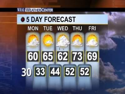
Most counties were under freeze warnings again overnight Sunday, adding stress to plants that had to handle atypical weather over previous nights. The predicted Monday night temperatures were expected to knock out state Department of Transportation plans to begin the repaving of Interstate 40 at 8 p.m.
Tar Heels were not alone in their shivering Sunday. Across much of the eastern two-thirds of the nation, Easter celebrants swapped frills, bonnets and sandals for coats, scarves and heavy socks. Baseball fans huddled in blankets and, instead of spring planting, backyard gardeners were bundling their crops.
Continued cold Monday ought not to be a surprise for Triangle residents. Several National Weather Stations reported record low temperatures on Sunday. At Raleigh-Durham International Airport, both the overnight low and daytime high on Sunday were about 15 degrees below normal.
Atlanta had a low of 30 degrees Sunday, with a wind chill of 23, the National Weather Service said. The same reading hit New York City's Fifth Avenue, celebrated in song for the traditional Easter Parade of spring finery.
In the city of Chardon, Ohio, east of Cleveland, about 16 inches of snow had fallen, and forecasters predicted the region could get another 10 inches before the storms tapered off late Sunday. Temperatures were expected to remain unseasonably cold through much of the week.
The Cleveland Indians tried all weekend to kick off their series against the Seattle Mariners, but were stymied when the weather forced Friday's home opener and subsequent double headers on Saturday and Sunday to be postponed.
Copyright 2024 by WRAL.com and the Associated Press. All rights reserved. This material may not be published, broadcast, rewritten or redistributed.


