Chapel Hill cleans up, inspects flood damage
Authorities fanned out across water-logged Chapel Hill on Monday to inspect property damage left from a soggy night of near-record rainfall and flash flooding. Teams were working to determine whether the area qualifies for disaster relief funds.
Posted — UpdatedTeams of firefighters, police officers and public works employees were getting an accurate count of how many homes and vehicles were battered by floodwater, and checking for structural and environmental damage caused by heavy storms that rolled through the region.
They were also working to determine whether the area qualifies for disaster relief funds.
"Emergency crews are doing everything within their expertise to make the town a safe and livable place for all," town spokeswoman Lisa Edwards said in a statement. "Emergency crews will be monitoring situations throughout the town during the next 48 hours."
A total of 4.66 inches of rain fell in Chapel Hill on Sunday, according to data from the State Climate Office. Another 2 to 4 inches of rain could hit the Triangle by Tuesday, bringing the potential for more flooding.
Dozens of counties, including Orange, Durham and Wake, remain under a flash flood watch through 6 p.m. Wednesday.
"What we're most concerned about is the same area seeing the same rain over and over," WRAL meteorologist Elizabeth Gardner said. "That's what happened in Chapel Hill Sunday."
Heavy rains and flooding Sunday affected an estimated 150 people in Orange County. Forty people had to be rescued, including 25 residents from Rocky Brook Mobile Home Park on South Greensboro Street in Carrboro.
Residents were also forced to leave their homes in Camelot Village, near University Mall, on Estes Drive in Chapel Hill. Estes Drive was closed, and Orange County Emergency Services reported the parking lot of Shops at Eastgate was also under water.
Chapel Hill firefighters said they responded to 56 emergency calls in a 24-hour period.
Bolin Creek and multiple locations on Franklin Street were flooded with as much as 4 to 6 feet of water, and numerous cars were stalled in water.
There were also downed trees and power outages. At one point Sunday night, about 2,100 Duke Energy Progress customers were without electricity in Durham; about 1,000 were without power in Orange County.
"I'm out here because I can't get home," Chapel Hill resident Grace Turrentine said Sunday. "I've never seen this much water where it's not supposed to be, in my life."
The Triangle Chapter of the American Red Cross opened a shelter at Smith Middle School, 9201 Seawell School Road in Chapel Hill. People with special needs, as well as pets, are being accommodated. About 40 people had taken advantage of the shelter Sunday night, American Red Cross officials said.
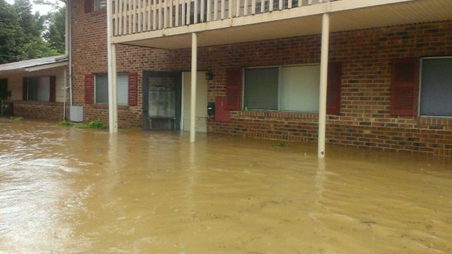
The water flushed Michael Stephenson out of his home in Camelot Village. His furniture, belongings and car were all damaged or destroyed.
"I won't be living here anymore," he said. "It is just a crazy experience."
Dwayne Hayes spent the night at Smith Middle School after fleeing his flooded condominium at the complex on Estes Drive. He said he’s lived in Chapel Hill since 1975 and has seen serious flooding only once before, during a hurricane.
“This one came on us fast. The water rose so quickly, we couldn’t even leave our apartments because you could not open the doors,” he said. “I’ve never seen anything like this.”
Hayes said the water was “like a river” and waist deep in some areas. He’s not sure when he will be able to return home.
“Everything I own is wet,” Hayes said. “This is difficult.”
Brian Owens also evacuated from Camelot Village on Sunday night as water rushed into his residence.
"It was pretty much a mad scene," Owens said. "Chaos everywhere."
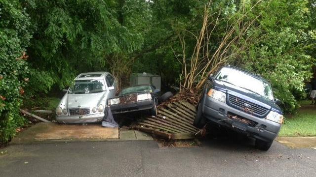
He returned home Monday morning to find floodwater had displaced parked cars and soaked belongings.
Seventy-six of the 116 units at Camelot Village, which is a mix of privately owned and managed units, flooded Sunday. Renters said Monday they have been told to remove their property so repair work can begin.
Chapel Hill officials on Monday closed the first floor town hall and the playgrounds at Umstead Park and the Chapel Hill Community Center because of flooding or debris cleanup.
Granville Towers at the University of North Carolina at Chapel Hill also took on several feet of water in the basement. Cleanup crews were pumping out the water Monday afternoon from the west tower. No students are living the building during summer break, officials said.
Flooding also caused problems Sunday in Durham, where cars were stalled along Garrett and Hope Valley roads. Roxboro Road was also flooded in multiple spots.
In Chatham County, rain fell moderately over areas south of Pittsboro, causing flooding and road closures on Mount Gilead Church Road and Sanford Road.
Raleigh was spared from serious flooding.
Crabtree Creek, which often floods the Crabtree Valley Mall property during heavy rain, was muddy and swollen Monday but stayed within its banks. The mall closed the lowest parking levels as a precaution, but stores remained open.
The chance for stormy weather will linger early in the work week, although the temperatures will hover in the mid-80s instead of low 90s. The humidity will remain high, Gardner said.
"More is definitely coming," she said. "We're in this pattern where it's like someone opened up the fire hose and aimed it at North Carolina."
The National Weather Service advises motorists to refrain from driving into areas where water covers roads. As little as 6 inches of water can cause a driver to lose control. Two feet of rushing water can carry away most vehicles, including SUVs and pickups.
Skies over the Triangle were clear before dawn Monday, but heavy rain was falling to the west and moving east. Moisture flowing up from the south could fire up additional storms.
The chance of thunderstorms will decrease by the weekend, which is expected to be dry and hot. Temperatures will climb back into the 90s on Saturday and Sunday.
• Credits
Copyright 2024 by Capitol Broadcasting Company. All rights reserved. This material may not be published, broadcast, rewritten or redistributed.


