Bring back the heat: Widespread 90s expected Wednesday
Raleigh-Durham International Airport hasn't reached 90 degrees yet in 2013, bucking a trend that has held up for more than 125 years, WRAL meteorologist Mike Moss said.
Posted — Updated
Raleigh-Durham International Airport hasn't reached 90 degrees yet in 2013, bucking a trend that has held up for more than 125 years, WRAL meteorologist Mike Moss said.
"Since 1887, the average date for Raleigh's first 90-degree day is May 10, according to the Southeast Regional Climate Center," Moss said. "Obviously, things have been quite different this spring."
The first 90-degree day last year came on May 2, and by June 12 temperatures had cracked 90 degrees at RDU five times. The latest 90-degree day since 1887 came in 1983, when highs didn't top 90 degrees at RDU until June 27.
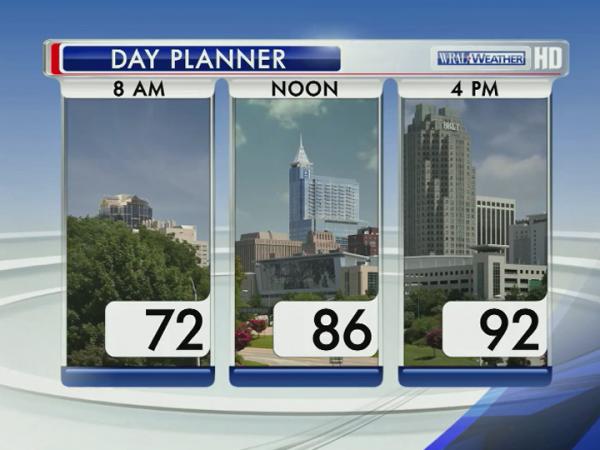
By 3 p.m. Wednesday, RDU had measured 86 degrees, and the temperature sensor at WRAL Studios was stuck at 89.
Following Wednesday's first trip into the 90s, Thursday's highs will climb even higher, likely topping out near 95 degrees.
"We'll get very warm tomorrow, but we'll be breezy ahead of a cold front that is going to bring us a chance for strong to severe storms during the afternoon and evening," Moss said.
Storms associated with the front were lining up across the Midwest early Wednesday were expected to impact millions of Americans from Iowa to Maryland throughout the day.


The Triangle will see an elevated risk for severe weather Thursday evening as the system moves through the Mid-Atlantic, with the biggest threat coming from straight-line winds and hail.
"Our best chance for storms will be during the late afternoon and evening Thursday, so keep an eye on any watches or warnings that may be generated by these storms," Moss said.
Once the system clears, cooler air will filter into the Triangle for the final day of the work week and the weekend.
Highs Friday, Saturday and Sunday will top out in the mid-80s under partly cloudy to mostly sunny skies.

• Credits
Copyright 2024 by Capitol Broadcasting Company. All rights reserved. This material may not be published, broadcast, rewritten or redistributed.


