'Impressive' Andrea leaves rain-soaked NC behind
Tropical Storm Andrea swept out of North Carolina Friday evening, bringing an end to a chaotic day of flash flooding, power outages, downed trees and more than 5 inches of rain.
Posted — UpdatedNo injuries were reported, but several homes were damaged by felled trees and dozens of drivers had close calls after steering their vehicles into floodwaters. Raleigh firefighters rescued four women from their van after it got stuck in standing water on TW Alexander Drive at Glenwood Avenue.
“Each tropical storm has its own characteristics and this one will be remembered as a huge rainmaker, bigger than Hurricane Fran back in 1996,” he said. “It was fast moving for a tropical storm.”
Andrea – the first named storm of the 2013 hurricane season – made landfall at 5:45 p.m. Thursday in Florida’s Big Bend area with maximum sustained winds near 65 mph. The storm trekked quickly through Georgia and South Carolina before arriving in North Carolina early Friday morning.
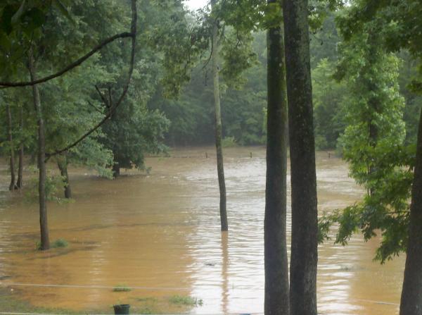
Andrea packed two waves of heavy rain, with the first rolling through Friday morning and the second coming in the afternoon. The drenching brought more rain in one day than is typical for the entire month of June. The average June rainfall in Raleigh is 3.42 inches.
“We’ve had 6.02 inches of rain for the month, and the month’s not even half over yet,” Maze said.
Widespread flooding occurred in low-lying and creekside communities throughout Raleigh, Durham, Cary, Apex, Clayton and other areas.
Raleigh police closed briefly closed Lake Boone Trail at Interstate 440 just south of Rex Hospital, where standing water was inhibiting travel.
Glenwood Avenue in north Raleigh also closed briefly in the late afternoon when flood waters overwhelmed storm drains and pooled on the road. Up to 4 inches of water was reported on Glenwood Avenue between Millbrook and Hillburn roads.
Crabtree Valley Mall, which often floods during heavy rain, closed around 5 p.m. as a precaution after water rose in the front parking area. The National Weather Service said Crabtree Creek, which runs by the mall, was above the 18-foot flood stage.
"We do not have any water in the confines of our building," mall spokesperson Christy Alphin said. "We're very fortunate. It's just been in those low-lying areas in the parking deck."
The Neuse River was rising and was expected to crest Saturday. The rising water flooded greenways in Clayton.
Significant power outages were reported throughout the region Friday afternoon. Duke Energy Progress reported 9,000 customers without power about 4:30 p.m.
Residents of the Sherwood Greens neighborhood in Cary said residential streets there were almost impassable. In Durham, trees were knocked down near Interstate 40 and N.C. Highway 54 and at Rugby and Darwin roads, but no serious flooding was reported.
In Apex, graduation rehearsal for high school seniors was canceled Friday evening over worries about weather and road conditions.
While the weather impacted road traffic, it had little effect on air travel. Officials at Raleigh-Durham International Airport said four flights were rerouted and a few were delayed, but none was canceled.
In Franklin County, runoff from the storm overwhelmed the sewer system and caused about 20,000 gallons of untreated sewage to spill into a tributary of Cedar Creek, officials said. Crews worked through the evening to clear the problem and said they would return Saturday.
Both games of the NCAA Baseball playoffs planned in the Triangle for Friday were pushed back to Saturday. The University of North Carolina will face South Carolina Saturday at 12:05 p.m. (EPSN) and North Carolina State University meets Rice at 4 p.m. (ESPN2).
By 5 p.m., Andrea had lost most of her punch and was moving quickly northward. The storm was classified as “post-tropical” at that point, meaning it was no longer deriving its power from moist, tropical air.
Despite the drenching, Andrea won’t go down in the history books as a particularly destructive storm.
“This was not the worst flooding we’ve ever seen,” Maze said. “We’ve had instances where the mall was flooded, Wake Forest Road and all the car dealerships there were flooded. This was not a major flooding event, but this was impressive.”
The Triangle won’t have much chance to dry out.
Another system was moving across the Southeast late Friday and is expected to roll into North Carolina on Saturday, bringing more rain.


• Credits
Copyright 2024 by WRAL.com and the Associated Press. All rights reserved. This material may not be published, broadcast, rewritten or redistributed.


